
Carte topographique کالا باغ
Carte interactive
Cliquez sur la carte pour afficher l’altitude.
À propos de cette carte
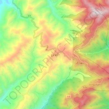
Nom : Carte topographique کالا باغ, altitude, relief.
Lieu : کالا باغ, Khyber Pakhtunkhwa, Pakistan (34.03414 73.33085 34.11414 73.41085)
Altitude moyenne : 2’122 m
Altitude minimum : 1’408 m
Altitude maximum : 2’959 m
Autres cartes topographiques
Cliquez sur une carte pour visualiser sa topographie, son altitude et son relief.
Peshāwar District
Pakistan > Khyber Pakhtunkhwa > Peshāwar District
Peshāwar District, Khyber Pakhtunkhwa, Pakistan
Altitude moyenne : 684 m
Hindu Kush
Hindu Kush, Chitrāl District, Khyber Pakhtunkhwa, Pakistan
Altitude moyenne : 5’281 m
Bannu
Pakistan > Khyber Pakhtunkhwa > Bannu
Bannu, Bannu District, Khyber Pakhtunkhwa, 28100, Pakistan
Altitude moyenne : 435 m
Nowshera
Pakistan > Khyber Pakhtunkhwa > Nowshera
Nowshera, Peshāwar District, Khyber Pakhtunkhwa, 24100, Pakistan
Altitude moyenne : 393 m
بشام
Pakistan > Khyber Pakhtunkhwa > بشام
بشام, شانگلہ, Khyber Pakhtunkhwa, 20500, Pakistan
Altitude moyenne : 1’226 m
Khyber Pakhtunkhwa
Khyber Pakhtunkhwa, Pakistan
Altitude moyenne : 2’135 m