
Faire un don
Équipez-vous pour votre prochaine aventure :
En tant que Partenaire Amazon, ce site perçoit une commission sur les achats éligibles sans surcoût pour vous.
Carte topographique Merkslohberg
Cliquez sur la carte pour afficher l’altitude.
Faire un don
Équipez-vous pour votre prochaine aventure :
En tant que Partenaire Amazon, ce site perçoit une commission sur les achats éligibles sans surcoût pour vous.
À propos de cette carte
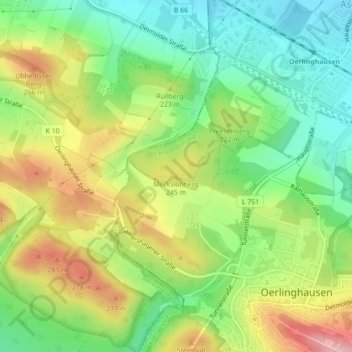
Nom : Carte topographique Merkslohberg, altitude, relief.
Altitude moyenne : 209 m
Altitude minimum : 141 m
Altitude maximum : 303 m
Faire un don
Équipez-vous pour votre prochaine aventure :
En tant que Partenaire Amazon, ce site perçoit une commission sur les achats éligibles sans surcoût pour vous.
Autres cartes topographiques
Cliquez sur une carte pour visualiser sa topographie, son altitude et son relief.
Leopoldshöhe
Deutschland > Nordrhein-Westfalen > Kreis Lippe > Leopoldshöhe
Leopoldshöhe (plattdeutsch: Höchte) ist eine Gemeinde im Kreis Lippe. Sie liegt zentral in Ostwestfalen-Lippe, einer Region im Nordosten des Landes Nordrhein-Westfalen, und grenzt im Westen an die kreisfreie Stadt Bielefeld.
Altitude moyenne : 119 m