
Carte topographique Faxon
Carte interactive
Cliquez sur la carte pour afficher l’altitude.
À propos de cette carte
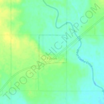
Nom : Carte topographique Faxon, altitude, relief.
Lieu : Faxon, Comanche County, Oklahoma, United States (34.45518 -98.58372 34.46406 -98.57487)
Altitude moyenne : 334 m
Altitude minimum : 325 m
Altitude maximum : 345 m
Autres cartes topographiques
Cliquez sur une carte pour visualiser sa topographie, son altitude et son relief.
Academic Hights
United States > Oklahoma > Comanche County > Lawton
Academic Hights, Lawton, Comanche County, Oklahoma, United States
Altitude moyenne : 348 m
Jackson Hole
United States > Oklahoma > Comanche County
Jackson Hole, Comanche County, Oklahoma, United States
Altitude moyenne : 406 m
Meers
United States > Oklahoma > Comanche County
Meers, Comanche County, Oklahoma, United States
Altitude moyenne : 457 m
Lake Lawtonka
United States > Oklahoma > Comanche County
Lake Lawtonka, Comanche County, Oklahoma, United States
Altitude moyenne : 428 m
Lawton
United States > Oklahoma > Comanche County
Lawton, Comanche County, Oklahoma, United States
Altitude moyenne : 352 m
Indiahoma
United States > Oklahoma > Comanche County
Indiahoma, Comanche County, Oklahoma, United States
Altitude moyenne : 405 m
Geronimo
United States > Oklahoma > Comanche County
Geronimo, Comanche County, Oklahoma, 73543, United States
Altitude moyenne : 328 m
Chattanooga
United States > Oklahoma > Comanche County
Chattanooga, Comanche County, Oklahoma, 73528, United States
Altitude moyenne : 347 m
Sterling
United States > Oklahoma > Comanche County
Sterling, Comanche County, Oklahoma, 73567, United States
Altitude moyenne : 372 m
Fletcher
United States > Oklahoma > Comanche County
Fletcher, Comanche County, Oklahoma, United States
Altitude moyenne : 417 m
Cache
United States > Oklahoma > Comanche County
Cache, Comanche County, Oklahoma, 73527, United States
Altitude moyenne : 386 m
Fort Sill
United States > Oklahoma > Comanche County
Fort Sill, Comanche County, Oklahoma, United States
Altitude moyenne : 417 m
Elk Mountain
United States > Oklahoma > Comanche County
Elk Mountain, Comanche County, Oklahoma, United States
Altitude moyenne : 543 m
Elgin
United States > Oklahoma > Comanche County
Elgin, Comanche County, Oklahoma, United States
Altitude moyenne : 393 m
Pratt Hill
United States > Oklahoma > Comanche County
Pratt Hill, Comanche County, Oklahoma, 73557, United States
Altitude moyenne : 442 m
Lawton
United States > Oklahoma > Comanche County > Lawton
Lawton, Comanche County, Oklahoma, 73501, United States
Altitude moyenne : 361 m
Mount McKinley
United States > Oklahoma > Comanche County
Mount McKinley, Comanche County, Oklahoma, United States
Altitude moyenne : 498 m
Cove Acres
United States > Oklahoma > Comanche County > Cove Acres
Cove Acres, Comanche County, Oklahoma, 73006, United States
Altitude moyenne : 381 m
Cross Mountain
United States > Oklahoma > Comanche County
Cross Mountain, Comanche County, Oklahoma, United States
Altitude moyenne : 530 m
Medicine Park
United States > Oklahoma > Comanche County
Medicine Park, Comanche County, Oklahoma, 73557, United States
Altitude moyenne : 429 m