
Carte topographique Diamondhead
Carte interactive
Cliquez sur la carte pour afficher l’altitude.
À propos de cette carte
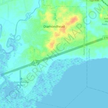
Nom : Carte topographique Diamondhead, altitude, relief.
Altitude moyenne : 6 m
Altitude minimum : -4 m
Altitude maximum : 34 m
Much of the land that became Diamondhead had been purchased by Walter Gex Sr., in 1937 from the Gulf State Paper Company and the Easy Opener Bag Company. Additional land was purchased by Gex, bringing his acquisition to nearly 5,000 acres (2,000 ha). In the late 1960s, D.E.A.R., Inc., later known as the Diamondhead Corporation, a large corporation interested in resort developments, began operations on the Mississippi Coast, with Diamondhead as its first project. Coastal Mississippi had been a popular vacation destination for years, particularly with Midwesterners. Its location was ideal as a second home development given the convenient access via Interstate 55. The land on which Diamondhead is located is the highest point of elevation (100 feet (30 m) above sea level) on the Gulf Coast in Mississippi. Therefore, the project was named "Diamondhead" after Diamond Head, an iconic volcanic cone on the Hawaiian island of Oahu.
Autres cartes topographiques
Cliquez sur une carte pour visualiser sa topographie, son altitude et son relief.
Bay Saint Louis
United States > Mississippi > Hancock County
Bay Saint Louis, Hancock County, Mississippi, United States
Altitude moyenne : 2 m
Pearlington
United States > Mississippi > Hancock County
Pearlington, Hancock County, Mississippi, United States
Altitude moyenne : 3 m
Kiln
United States > Mississippi > Hancock County > Kiln
Kiln, Hancock County, Mississippi, United States
Altitude moyenne : 11 m