
Carte topographique Carbonton Heights
Carte interactive
Cliquez sur la carte pour afficher l’altitude.
À propos de cette carte
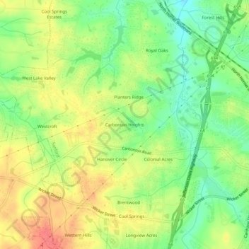
Nom : Carte topographique Carbonton Heights, altitude, relief.
Altitude moyenne : 105 m
Altitude minimum : 74 m
Altitude maximum : 138 m
Autres cartes topographiques
Cliquez sur une carte pour visualiser sa topographie, son altitude et son relief.
Sunset Terrace
United States > North Carolina > Lee County > Sanford
Sunset Terrace, Sanford, Lee County, North Carolina, 27339, United States
Altitude moyenne : 114 m
Colonial Acres
United States > North Carolina > Lee County > Sanford
Colonial Acres, Sanford, Lee County, North Carolina, 27339, United States
Altitude moyenne : 106 m
Hanover Circle
United States > North Carolina > Lee County > Sanford
Hanover Circle, Sanford, Lee County, North Carolina, 27339, United States
Altitude moyenne : 108 m
Brookwood
United States > North Carolina > Lee County > Sanford
Brookwood, Sanford, Lee County, North Carolina, 27339, United States
Altitude moyenne : 105 m
Cool Springs Estates
United States > North Carolina > Lee County > Sanford > Cool Springs Estates
Cool Springs Estates, Sanford, Lee County, North Carolina, 27330, United States
Altitude moyenne : 98 m
Forest Hills
United States > North Carolina > Lee County > Sanford > Forest Hills
Forest Hills, Sanford, Lee County, North Carolina, 27330, United States
Altitude moyenne : 98 m
McCracken Heights
United States > North Carolina > Lee County > Sanford
McCracken Heights, Sanford, Lee County, North Carolina, 27330, United States
Altitude moyenne : 103 m
Berkley Place
United States > North Carolina > Lee County > Sanford > Berkley Place
Berkley Place, Sanford, Lee County, North Carolina, 27339, United States
Altitude moyenne : 116 m