
Carte topographique Zenica
Carte interactive
Cliquez sur la carte pour afficher l’altitude.
À propos de cette carte
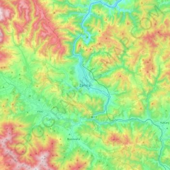
Nom : Carte topographique Zenica, altitude, relief.
Altitude moyenne : 730 m
Altitude minimum : 251 m
Altitude maximum : 1’663 m
The city is geographically located in the heart of Bosnia. The settled area is 43.01 km2 (16.61 sq mi) and of the city proper covers 558.5 km2 (215.6 sq mi). Elevation is 310–350 m (1,017–1,148 ft). The rivers Bosna, Lašva, Babina, and Kočeva flow through the settlement. A moderate continental climate prevails. The city has thirteen urban local settlements and it consists of a total of 81 rural settlements.
Autres cartes topographiques
Cliquez sur une carte pour visualiser sa topographie, son altitude et son relief.
Stranjani
Bosnia and Herzegovina > Federation of Bosnia and Herzegovina > City of Zenica
Stranjani, City of Zenica, Zenica-Doboj Canton, Federation of Bosnia and Herzegovina, Bosnia and Herzegovina
Altitude moyenne : 648 m