
Faire un don
Équipez-vous pour votre prochaine aventure :
En tant que Partenaire Amazon, ce site perçoit une commission sur les achats éligibles sans surcoût pour vous.
Carte topographique Patata
Cliquez sur la carte pour afficher l’altitude.
Faire un don
Équipez-vous pour votre prochaine aventure :
En tant que Partenaire Amazon, ce site perçoit une commission sur les achats éligibles sans surcoût pour vous.
À propos de cette carte
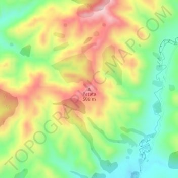
Nom : Carte topographique Patata, altitude, relief.
Altitude moyenne : 356 m
Altitude minimum : 220 m
Altitude maximum : 519 m
Faire un don
Équipez-vous pour votre prochaine aventure :
En tant que Partenaire Amazon, ce site perçoit une commission sur les achats éligibles sans surcoût pour vous.
Autres cartes topographiques
Cliquez sur une carte pour visualiser sa topographie, son altitude et son relief.
Tongariro National Park
New Zealand > Manawatu-Whanganui > Ruapehu District
The first activities in the young Tongariro National Park were the construction of tourist huts at the beginning of the 20th century. But it was not before opening of the railway in 1908 and the building of roads in the 1930s that a significant number of people visited the park. The second Tongariro National…
Altitude moyenne : 888 m