
Carte topographique Gallatin National Forest
Carte interactive
Cliquez sur la carte pour afficher l’altitude.
À propos de cette carte
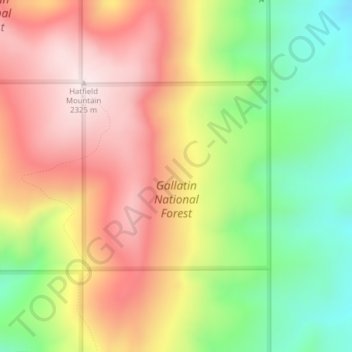
Nom : Carte topographique Gallatin National Forest, altitude, relief.
Altitude moyenne : 2’064 m
Altitude minimum : 1’785 m
Altitude maximum : 2’326 m
Autres cartes topographiques
Cliquez sur une carte pour visualiser sa topographie, son altitude et son relief.
Bozeman
United States > Montana > Gallatin County
Bozeman, Gallatin County, Montana, United States
Altitude moyenne : 1’495 m
Big Sky
United States > Montana > Gallatin County
Big Sky, Gallatin County, Montana, United States
Altitude moyenne : 2’435 m
West Yellowstone
United States > Montana > Gallatin County
West Yellowstone, Gallatin County, Montana, United States
Altitude moyenne : 2’034 m
Logan
United States > Montana > Gallatin County
Logan, Gallatin County, Montana, United States
Altitude moyenne : 1’294 m
Clarkston
United States > Montana > Gallatin County
Clarkston, Gallatin County, Montana, United States
Altitude moyenne : 1’236 m
Gallatin River
United States > Montana > Gallatin County
Gallatin River, Gallatin Gateway, Gallatin County, Montana, United States
Altitude moyenne : 1’509 m
Manhattan
United States > Montana > Gallatin County
Manhattan, Gallatin County, Montana, United States
Altitude moyenne : 1’294 m
Three Forks
United States > Montana > Gallatin County
Three Forks, Gallatin County, Montana, United States
Altitude moyenne : 1’249 m
Four Corners
United States > Montana > Gallatin County
Four Corners, Gallatin County, Montana, United States
Altitude moyenne : 1’469 m
Bozeman
United States > Montana > Gallatin County > Bozeman
Bozeman, Gallatin County, Montana, 59715, United States
Altitude moyenne : 1’679 m
Big Sky Canyon Village
United States > Montana > Gallatin County > Big Sky Canyon Village
Big Sky Canyon Village, Gallatin County, Montana, United States
Altitude moyenne : 1’994 m
Belgrade
United States > Montana > Gallatin County
Belgrade, Gallatin County, Montana, 59714, United States
Altitude moyenne : 1’355 m