
Carte topographique Grant
Carte interactive
Cliquez sur la carte pour afficher l’altitude.
À propos de cette carte
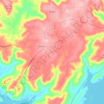
Nom : Carte topographique Grant, altitude, relief.
Lieu : Grant, Marshall County, Alabama, 35847, United States (34.45696 -86.28289 34.53761 -86.19251)
Altitude moyenne : 300 m
Altitude minimum : 179 m
Altitude maximum : 392 m
Grant is located in northeastern Marshall County at an elevation of 1,240 feet (380 m) on the plateau of Gunters Mountain. The town is concentrated along County Road 5 (Cathedral Caverns Highway, signed as Main Street in Grant) near the northern edge of Gunters Mountain, though the town includes corridors along CR 5 southward across the mountain to the shore of Guntersville Lake, and eastward along Baker Mountain Road to the edge of the mountain. Grant is 13 miles (21 km) north of Guntersville, 18 miles (29 km) southwest of Scottsboro, and 30 miles (48 km) southeast of Huntsville.
Autres cartes topographiques
Cliquez sur une carte pour visualiser sa topographie, son altitude et son relief.
Guntersville
United States > Alabama > Marshall County
Guntersville, Marshall County, Alabama, 35976, United States
Altitude moyenne : 242 m
Needmore
United States > Alabama > Marshall County
Needmore, Marshall County, Alabama, United States
Altitude moyenne : 294 m
Albertville
United States > Alabama > Marshall County
Albertville, Marshall County, Alabama, 35950, United States
Altitude moyenne : 309 m
Bucksnort
United States > Alabama > Marshall County
Bucksnort, Marshall County, Alabama, 35747, United States
Altitude moyenne : 289 m
Union Grove
United States > Alabama > Marshall County > Union Grove
Union Grove, Marshall County, Alabama, United States
Altitude moyenne : 300 m
Lake Guntersville State Park
United States > Alabama > Marshall County > Guntersville
Lake Guntersville State Park, Guntersville, Marshall County, Alabama, United States
Altitude moyenne : 242 m
Shoal Creek
United States > Alabama > Marshall County > Arab
Shoal Creek, Arab, Marshall County, Alabama, 35016, United States
Altitude moyenne : 327 m
Lindsay Lane
United States > Alabama > Marshall County > Guntersville
Lindsay Lane, Guntersville, Marshall County, Alabama, 35976, United States
Altitude moyenne : 249 m
Union Grove
United States > Alabama > Marshall County
Union Grove, Marshall County, Alabama, United States
Altitude moyenne : 299 m
Boaz
United States > Alabama > Marshall County
Boaz, Marshall County, Alabama, 35957, United States
Altitude moyenne : 320 m
Wyeth City
United States > Alabama > Marshall County > Guntersville > Wyeth City
Wyeth City, Guntersville, Marshall County, Alabama, 35976, United States
Altitude moyenne : 230 m
Guntersville
United States > Alabama > Marshall County > Guntersville
Guntersville, Marshall County, Alabama, 35976, United States
Altitude moyenne : 208 m
Bob Mountain
United States > Alabama > Marshall County
Bob Mountain, Marshall County, Alabama, United States
Altitude moyenne : 206 m
Arab
United States > Alabama > Marshall County
Arab, Marshall County, Alabama, 35016, United States
Altitude moyenne : 314 m