
Carte topographique Kennesaw
Carte interactive
Cliquez sur la carte pour afficher l’altitude.
À propos de cette carte
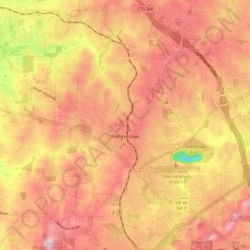
Nom : Carte topographique Kennesaw, altitude, relief.
Lieu : Kennesaw, Cobb County, Georgia, United States (33.98696 -84.65002 34.06690 -84.58092)
Altitude moyenne : 317 m
Altitude minimum : 167 m
Altitude maximum : 393 m
Kennesaw is located in northwestern Cobb County, bordered by the city of Acworth to the northwest. Kennesaw Mountain is located southeast of the city limits in the battlefield park. Its summit is the highest point in the Atlanta metro area, at an elevation of 1,808 feet (551 m) above sea level. The city was renamed for the mountain.
Autres cartes topographiques
Cliquez sur une carte pour visualiser sa topographie, son altitude et son relief.
Marietta
United States > Georgia > Cobb County
Marietta, Cobb County, Georgia, United States
Altitude moyenne : 323 m
Aboretum
United States > Georgia > Cobb County
Aboretum, Cobb County, Georgia, United States
Altitude moyenne : 319 m
Marietta
United States > Georgia > Cobb County > Marietta
Marietta, Cobb County, Georgia, 30090, United States
Altitude moyenne : 302 m
Kennesaw
United States > Georgia > Cobb County > Kennesaw
Kennesaw, Cobb County, Georgia, 30144, United States
Altitude moyenne : 318 m
Powder Springs
United States > Georgia > Cobb County
Powder Springs, Cobb County, Georgia, United States
Altitude moyenne : 291 m
Vinings
United States > Georgia > Cobb County > Vinings
Vinings, Cobb County, Georgia, 30339, United States
Altitude moyenne : 281 m
Smyrna
United States > Georgia > Cobb County
Smyrna, Cobb County, Georgia, United States
Altitude moyenne : 289 m
Acworth
United States > Georgia > Cobb County
Acworth, Cobb County, Georgia, United States
Altitude moyenne : 281 m