
Carte topographique Cap La Ronde
Carte interactive
Cliquez sur la carte pour afficher l’altitude.
À propos de cette carte
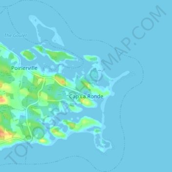
Nom : Carte topographique Cap La Ronde, altitude, relief.
Altitude moyenne : 2 m
Altitude minimum : -5 m
Altitude maximum : 35 m
Autres cartes topographiques
Cliquez sur une carte pour visualiser sa topographie, son altitude et son relief.
Battery Provincial Park
Canada > Nova Scotia > Municipality of the County of Richmond > St. Peter's
Battery Provincial Park, St. Peter's, Municipality of the County of Richmond, Richmond County, Nova Scotia, Canada
Altitude moyenne : 9 m
Louisdale
Canada > Nova Scotia > Municipality of the County of Richmond
Louisdale, Municipality of the County of Richmond, Richmond County, Nova Scotia, B0E 1V0, Canada
Altitude moyenne : 26 m
Potato Island
Canada > Nova Scotia > Municipality of the County of Richmond > Poirierville
Potato Island, Poirierville, Municipality of the County of Richmond, Richmond County, Nova Scotia, Canada
Altitude moyenne : 4 m
Thorn Creek
Canada > Nova Scotia > Municipality of the County of Richmond > Glasgow Point
Thorn Creek, Glasgow Point, Municipality of the County of Richmond, Richmond County, Nova Scotia, Canada
Altitude moyenne : 4 m
St. Peters Inlet
Canada > Nova Scotia > Municipality of the County of Richmond > Barra Head
St. Peters Inlet, Chapel Island 5, Barra Head, Municipality of the County of Richmond, Richmond County, Nova Scotia, Canada
Altitude moyenne : 17 m
Berry Island
Canada > Nova Scotia > Municipality of the County of Richmond > Martinique
Berry Island, Martinique, Municipality of the County of Richmond, Richmond County, Nova Scotia, B0E 1V0, Canada
Altitude moyenne : 41 m