
Carte topographique Tours
Cliquez sur la carte pour afficher l’altitude.
Tours
Tours a une altitude minimale de 44 m et une maximale de 109 m, son altitude moyenne est de 77 m tandis que celle de sa mairie est de 52 m environ.
À propos de cette carte
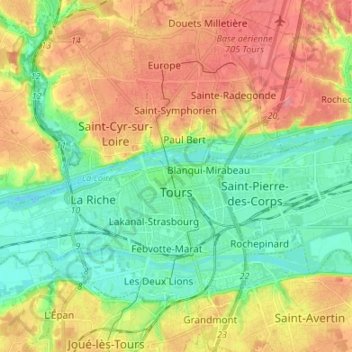
Nom : Carte topographique Tours, altitude, relief.
Altitude moyenne : 73 m
Altitude minimum : 40 m
Altitude maximum : 116 m
Autres cartes topographiques
Cliquez sur une carte pour visualiser sa topographie, son altitude et son relief.
Parc du Lac des Bretonnières
France > Centre-Val de Loire > Indre-et-Loire > Joué-lès-Tours > La Petite Carte
Altitude moyenne : 85 m
Le Bois Joly
France > Centre-Val de Loire > Indre-et-Loire > Tauxigny-Saint-Bauld
Altitude moyenne : 83 m
La Proutière
France > Centre-Val de Loire > Indre-et-Loire > Épeigné-sur-Dême
Altitude moyenne : 106 m
La Petite Carte
France > Centre-Val de Loire > Indre-et-Loire > Joué-lès-Tours
Altitude moyenne : 70 m
Chausseloup
France > Centre-Val de Loire > Indre-et-Loire > Chanceaux-sur-Choisille
Altitude moyenne : 96 m
La Terre de la Ceuille Roulée
France > Centre-Val de Loire > Indre-et-Loire > Langeais
Altitude moyenne : 89 m
Les Coutures
France > Centre-Val de Loire > Indre-et-Loire > La Ville-aux-Dames
Altitude moyenne : 57 m
La Foire de Saint-Roch
France > Centre-Val de Loire > Indre-et-Loire > Saint-Roch
Altitude moyenne : 96 m
Saint-Sulpice
France > Centre-Val de Loire > Indre-et-Loire > Chambourg-sur-Indre
Altitude moyenne : 90 m
Le Buisson
France > Centre-Val de Loire > Indre-et-Loire > Tauxigny-Saint-Bauld
Altitude moyenne : 97 m
La Grangette
France > Centre-Val de Loire > Indre-et-Loire > Montlouis-sur-Loire
Altitude moyenne : 59 m
Île de Porteau
France > Centre-Val de Loire > Indre-et-Loire > La Chapelle-sur-Loire
Altitude moyenne : 34 m
Les Chauvelles
France > Centre-Val de Loire > Indre-et-Loire > Azay-le-Rideau > Lionnière
Altitude moyenne : 81 m
La Grange du Bois
France > Centre-Val de Loire > Indre-et-Loire > Épeigné-les-Bois
Altitude moyenne : 105 m
La Tuilerie
France > Centre-Val de Loire > Indre-et-Loire > La Croix-en-Touraine
Altitude moyenne : 74 m
Château de Villandry
France > Centre-Val de Loire > Indre-et-Loire > Villandry > Le Château
Altitude moyenne : 64 m
Le Puy Mary
France > Centre-Val de Loire > Indre-et-Loire > Le Petit-Pressigny
Altitude moyenne : 123 m
La Vallée des Caves
France > Centre-Val de Loire > Indre-et-Loire > Rochecorbon
Altitude moyenne : 110 m
Le Carroi
France > Centre-Val de Loire > Indre-et-Loire > Mazières-de-Touraine
Altitude moyenne : 91 m
Parc du Val de Loire
France > Centre-Val de Loire > Indre-et-Loire > Montlouis-sur-Loire > Le Bourg
Altitude moyenne : 63 m
Les Ansaults
France > Centre-Val de Loire > Indre-et-Loire > Artannes-sur-Indre
Altitude moyenne : 73 m
Le Sabot Rouge
France > Centre-Val de Loire > Indre-et-Loire > Sainte-Maure-de-Touraine
Altitude moyenne : 98 m
La Blottière
France > Centre-Val de Loire > Indre-et-Loire > Beaumont-Louestault
Altitude moyenne : 121 m
Les Availlons
France > Centre-Val de Loire > Indre-et-Loire > Yzeures-sur-Creuse
Altitude moyenne : 93 m
La Brosse
France > Centre-Val de Loire > Indre-et-Loire > Fondettes > La Brosse
Altitude moyenne : 94 m
Les Sablons
France > Centre-Val de Loire > Indre-et-Loire > Cléré-les-Pins > Les Sablons
Altitude moyenne : 99 m
Le Chardonneret
France > Centre-Val de Loire > Indre-et-Loire > Nouzilly > Le Chardonneret
Altitude moyenne : 132 m
Le Val Joli
France > Centre-Val de Loire > Indre-et-Loire > Fondettes > Le Val Joli
Altitude moyenne : 80 m
La Petite Garenne
France > Centre-Val de Loire > Indre-et-Loire > Villaines-les-Rochers > La Petite Garenne
Altitude moyenne : 100 m
Château de Launay
France > Centre-Val de Loire > Indre-et-Loire > Pocé-sur-Cisse > Château de Launay
Altitude moyenne : 81 m
Les Tanneries
France > Centre-Val de Loire > Indre-et-Loire > Sainte-Maure-de-Touraine
Altitude moyenne : 95 m
Clos de Saint-Denis
France > Centre-Val de Loire > Indre-et-Loire > Amboise > Clos de Saint-Denis
Altitude moyenne : 80 m
Le Bois de la Grille
France > Centre-Val de Loire > Indre-et-Loire > Chinon > Le Villier
Altitude moyenne : 75 m
Saint-Nicolas-de-Bourgueil
France > Centre-Val de Loire > Indre-et-Loire > Saint-Nicolas-de-Bourgueil > Saint-Nicolas-de-Bourgueil
Altitude moyenne : 43 m
Bellevue
France > Centre-Val de Loire > Indre-et-Loire > La Chapelle-Blanche-Saint-Martin > Bellevue
Altitude moyenne : 115 m
Les Hucherolles
France > Centre-Val de Loire > Indre-et-Loire > Chinon > Les Hucherolles
Altitude moyenne : 57 m
Vienne
France > Centre-Val de Loire > Indre-et-Loire > Saint-Christophe-sur-le-Nais > Vienne
Altitude moyenne : 94 m
La Pointe Luneau
France > Centre-Val de Loire > Indre-et-Loire > Montlouis-sur-Loire > La Pointe Luneau
Altitude moyenne : 65 m
La Joncherie-sud
France > Centre-Val de Loire > Indre-et-Loire > Fondettes > La Joncherie-sud
Altitude moyenne : 78 m
Le Boulay
France > Centre-Val de Loire > Indre-et-Loire > Villedômer > Le Boulay
Altitude moyenne : 118 m