
Carte topographique Austrey CP
Cliquez sur la carte pour afficher l’altitude.
À propos de cette carte
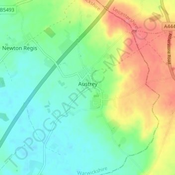
Nom : Carte topographique Austrey CP, altitude, relief.
Altitude moyenne : 91 m
Altitude minimum : 63 m
Altitude maximum : 139 m
Autres cartes topographiques
Cliquez sur une carte pour visualiser sa topographie, son altitude et son relief.
Brook End
United Kingdom > England > Warwickshire > North Warwickshire > Hurley
Altitude moyenne : 107 m
Gilson
United Kingdom > England > Warwickshire > North Warwickshire > Coleshill CP
Altitude moyenne : 82 m
Pooley Country Park
United Kingdom > England > Warwickshire > North Warwickshire > Polesworth
Altitude moyenne : 76 m
Hartshill Hayes Country Park
United Kingdom > England > Warwickshire > North Warwickshire > Ansley Common
Altitude moyenne : 127 m
Curdworth Locks
United Kingdom > England > Warwickshire > North Warwickshire > Kingsbury > Curdworth CP
Altitude moyenne : 80 m
Merevale Lake
United Kingdom > England > Warwickshire > North Warwickshire > Atherstone
Altitude moyenne : 119 m
Church End
United Kingdom > England > Warwickshire > North Warwickshire > Ansley CP
Altitude moyenne : 151 m
Holbech's Wood
United Kingdom > England > Warwickshire > North Warwickshire > Fillongley CP
Altitude moyenne : 140 m
Hoar Park
United Kingdom > England > Warwickshire > North Warwickshire > Bentley CP
Altitude moyenne : 135 m
Hunts Green
United Kingdom > England > Warwickshire > North Warwickshire > Middleton CP
Altitude moyenne : 81 m
Lea Marston Purification Lakes
United Kingdom > England > Warwickshire > North Warwickshire > Marston
Altitude moyenne : 70 m