
Carte topographique Rathenow
Carte interactive
Cliquez sur la carte pour afficher l’altitude.
À propos de cette carte
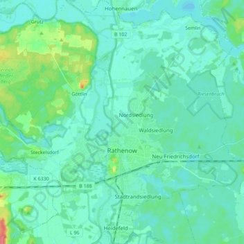
Nom : Carte topographique Rathenow, altitude, relief.
Lieu : Rathenow, Havelland, Brandenburg, Germany (52.56632 12.28418 52.67061 12.43091)
Altitude moyenne : 31 m
Altitude minimum : 22 m
Altitude maximum : 76 m
Autres cartes topographiques
Cliquez sur une carte pour visualiser sa topographie, son altitude et son relief.
Böhne
Germany > Brandenburg > Rathenow
Böhne, Rathenow, Havelland, Brandenburg, Germany
Altitude moyenne : 30 m