
Faire un don
Équipez-vous pour votre prochaine aventure :
En tant que Partenaire Amazon, ce site perçoit une commission sur les achats éligibles sans surcoût pour vous.
Carte topographique Neukirchen bei Sulzbach-Rosenberg
Cliquez sur la carte pour afficher l’altitude.
Faire un don
Équipez-vous pour votre prochaine aventure :
En tant que Partenaire Amazon, ce site perçoit une commission sur les achats éligibles sans surcoût pour vous.
À propos de cette carte
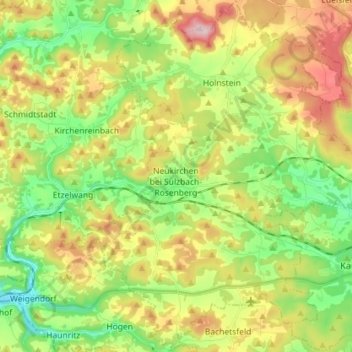
Nom : Carte topographique Neukirchen bei Sulzbach-Rosenberg, altitude, relief.
Altitude moyenne : 484 m
Altitude minimum : 375 m
Altitude maximum : 641 m
Faire un don
Équipez-vous pour votre prochaine aventure :
En tant que Partenaire Amazon, ce site perçoit une commission sur les achats éligibles sans surcoût pour vous.
Autres cartes topographiques
Cliquez sur une carte pour visualiser sa topographie, son altitude et son relief.
Neukirchen bei Sulzbach-Rosenberg
Deutschland > Bayern > Landkreis Amberg-Sulzbach
Altitude moyenne : 496 m
Faire un don
Équipez-vous pour votre prochaine aventure :
En tant que Partenaire Amazon, ce site perçoit une commission sur les achats éligibles sans surcoût pour vous.
Annaberg
Deutschland > Bayern > Landkreis Amberg-Sulzbach > Sulzbach-Rosenberg
Altitude moyenne : 421 m
Faire un don
Équipez-vous pour votre prochaine aventure :
En tant que Partenaire Amazon, ce site perçoit une commission sur les achats éligibles sans surcoût pour vous.
Trichenricht
Deutschland > Bayern > Landkreis Amberg-Sulzbach > Schnaittenbach
Altitude moyenne : 498 m
Faire un don
Équipez-vous pour votre prochaine aventure :
En tant que Partenaire Amazon, ce site perçoit une commission sur les achats éligibles sans surcoût pour vous.
Siebeneichen
Deutschland > Bayern > Landkreis Amberg-Sulzbach > Sulzbach-Rosenberg
Altitude moyenne : 425 m
Faire un don
Équipez-vous pour votre prochaine aventure :
En tant que Partenaire Amazon, ce site perçoit une commission sur les achats éligibles sans surcoût pour vous.
Welluck
Deutschland > Bayern > Landkreis Amberg-Sulzbach > Auerbach in der Oberpfalz > Welluck
Altitude moyenne : 465 m
Sackdilling
Deutschland > Bayern > Landkreis Amberg-Sulzbach > Auerbach in der Oberpfalz > Sackdilling
Altitude moyenne : 490 m
Faire un don
Équipez-vous pour votre prochaine aventure :
En tant que Partenaire Amazon, ce site perçoit une commission sur les achats éligibles sans surcoût pour vous.
Reichenbach
Deutschland > Bayern > Landkreis Amberg-Sulzbach > Auerbach in der Oberpfalz
Altitude moyenne : 468 m
Degelsdorf
Deutschland > Bayern > Landkreis Amberg-Sulzbach > Auerbach in der Oberpfalz
Altitude moyenne : 481 m
Faire un don
Équipez-vous pour votre prochaine aventure :
En tant que Partenaire Amazon, ce site perçoit une commission sur les achats éligibles sans surcoût pour vous.
Faire un don
Équipez-vous pour votre prochaine aventure :
En tant que Partenaire Amazon, ce site perçoit une commission sur les achats éligibles sans surcoût pour vous.
Faire un don
Équipez-vous pour votre prochaine aventure :
En tant que Partenaire Amazon, ce site perçoit une commission sur les achats éligibles sans surcoût pour vous.
Faire un don
Équipez-vous pour votre prochaine aventure :
En tant que Partenaire Amazon, ce site perçoit une commission sur les achats éligibles sans surcoût pour vous.
Faire un don
Équipez-vous pour votre prochaine aventure :
En tant que Partenaire Amazon, ce site perçoit une commission sur les achats éligibles sans surcoût pour vous.
Schönweiher
Deutschland > Bayern > Landkreis Amberg-Sulzbach > Sulzbach-Rosenberg > Forsthof
Altitude moyenne : 467 m
Michelfeld
Deutschland > Bayern > Landkreis Amberg-Sulzbach > Auerbach in der Oberpfalz
Altitude moyenne : 430 m
Faire un don
Équipez-vous pour votre prochaine aventure :
En tant que Partenaire Amazon, ce site perçoit une commission sur les achats éligibles sans surcoût pour vous.
Faire un don
Équipez-vous pour votre prochaine aventure :
En tant que Partenaire Amazon, ce site perçoit une commission sur les achats éligibles sans surcoût pour vous.
Seidersberg
Deutschland > Bayern > Landkreis Amberg-Sulzbach > Sulzbach-Rosenberg
Altitude moyenne : 439 m
Faire un don
Équipez-vous pour votre prochaine aventure :
En tant que Partenaire Amazon, ce site perçoit une commission sur les achats éligibles sans surcoût pour vous.
Stadionberg
Deutschland > Bayern > Landkreis Amberg-Sulzbach > Hirschbach > Oberklausen
Altitude moyenne : 478 m
Oberklausen
Deutschland > Bayern > Landkreis Amberg-Sulzbach > Hirschbach > Oberklausen
Altitude moyenne : 479 m
Neuersdorf
Deutschland > Bayern > Landkreis Amberg-Sulzbach > Schnaittenbach > Neuersdorf
Altitude moyenne : 445 m
Faire un don
Équipez-vous pour votre prochaine aventure :
En tant que Partenaire Amazon, ce site perçoit une commission sur les achats éligibles sans surcoût pour vous.
Ransbach
Deutschland > Bayern > Landkreis Amberg-Sulzbach > Hohenburg > Ransbach
Altitude moyenne : 463 m
Sand
Deutschland > Bayern > Landkreis Amberg-Sulzbach > Auerbach in der Oberpfalz
Altitude moyenne : 454 m
Faire un don
Équipez-vous pour votre prochaine aventure :
En tant que Partenaire Amazon, ce site perçoit une commission sur les achats éligibles sans surcoût pour vous.
Faire un don
Équipez-vous pour votre prochaine aventure :
En tant que Partenaire Amazon, ce site perçoit une commission sur les achats éligibles sans surcoût pour vous.
Mertenberg
Deutschland > Bayern > Landkreis Amberg-Sulzbach > Kemnath am Buchberg
Altitude moyenne : 540 m