
Carte topographique Gallipolis
Carte interactive
Cliquez sur la carte pour afficher l’altitude.
À propos de cette carte
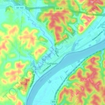
Nom : Carte topographique Gallipolis, altitude, relief.
Lieu : Gallipolis, Gallia County, Ohio, United States (38.79311 -82.22809 38.83919 -82.14937)
Altitude moyenne : 203 m
Altitude minimum : 165 m
Altitude maximum : 278 m
Winters are cold, with an average January temperature of 34.3 °F (1.3 °C). Snowfall is generally very light, with a mean average snowfall of 10.9 inches (280 mm). The village does not experience by lake-effect snow, although the village's weather can be influenced by the Great Lakes and regional topography. On average, there are 109 nights per year when the temperature drops to or below freezing, and only 14 days when the temperature fails to rise above freezing. Summers are hot and humid, with an average July temperature of 78.6 °F (25.9 °C). There are an average of 39 days per year with highs at or above 90 °F (32 °C).
Autres cartes topographiques
Cliquez sur une carte pour visualiser sa topographie, son altitude et son relief.
Gallia County Fairgrounds
United States > Ohio > Gallia County
Gallia County Fairgrounds, Springfield Township, Gallia County, Ohio, 45631, United States
Altitude moyenne : 200 m
Evergreen
United States > Ohio > Gallia County
Evergreen, Springfield Township, Gallia County, Ohio, 45614, United States
Altitude moyenne : 219 m
Northup
United States > Ohio > Gallia County
Northup, Green Township, Gallia County, Ohio, United States
Altitude moyenne : 204 m
Centerville
United States > Ohio > Gallia County
Centerville, Gallia County, Ohio, United States
Altitude moyenne : 221 m
Rio Grande
United States > Ohio > Gallia County
Rio Grande, Gallia County, Ohio, United States
Altitude moyenne : 209 m
Harrisburg
United States > Ohio > Gallia County
Harrisburg, Raccoon Township, Gallia County, Ohio, 45674, United States
Altitude moyenne : 205 m
Mercerville
United States > Ohio > Gallia County
Mercerville, Guyan Township, Gallia County, Ohio, 45623, United States
Altitude moyenne : 245 m
Porter
United States > Ohio > Gallia County
Porter, Springfield Township, Gallia County, Ohio, 45614, United States
Altitude moyenne : 222 m
Bidwell
United States > Ohio > Gallia County
Bidwell, Springfield Township, Gallia County, Ohio, 45614, United States
Altitude moyenne : 216 m
Adamsville
United States > Ohio > Gallia County
Adamsville, Raccoon Township, Gallia County, Ohio, 45674, United States
Altitude moyenne : 203 m
Ewington
United States > Ohio > Gallia County
Ewington, Huntington Township, Gallia County, Ohio, 45686, United States
Altitude moyenne : 210 m
Rodney
United States > Ohio > Gallia County
Rodney, Green Township, Gallia County, Ohio, United States
Altitude moyenne : 215 m
Kanauga
United States > Ohio > Gallia County
Kanauga, Gallipolis Township, Gallia County, Ohio, 25106, United States
Altitude moyenne : 187 m
Centerpoint
United States > Ohio > Gallia County
Centerpoint, Perry Township, Gallia County, Ohio, United States
Altitude moyenne : 235 m
Gallia
United States > Ohio > Gallia County
Gallia, Greenfield Township, Gallia County, Ohio, United States
Altitude moyenne : 224 m
Kerr
United States > Ohio > Gallia County
Kerr, Springfield Township, Gallia County, Ohio, 45614, United States
Altitude moyenne : 205 m
Springfield Township
United States > Ohio > Gallia County
Springfield Township, Gallia County, Ohio, 45614, United States
Altitude moyenne : 215 m
Vinton
United States > Ohio > Gallia County
Vinton, Gallia County, Ohio, 45686, United States
Altitude moyenne : 207 m
Patriot
United States > Ohio > Gallia County
Patriot, Perry Township, Gallia County, Ohio, 45658, United States
Altitude moyenne : 225 m
Cheshire
United States > Ohio > Gallia County
Cheshire, Gallia County, Ohio, United States
Altitude moyenne : 180 m
Crown City
United States > Ohio > Gallia County
Crown City, Gallia County, Ohio, United States
Altitude moyenne : 202 m
Bulaville
United States > Ohio > Gallia County
Bulaville, Addison Township, Gallia County, Ohio, United States
Altitude moyenne : 206 m
Kyger
United States > Ohio > Gallia County
Kyger, Cheshire Township, Gallia County, Ohio, 45620, United States
Altitude moyenne : 220 m