
Carte topographique Hambleton
Cliquez sur la carte pour afficher l’altitude.
À propos de cette carte
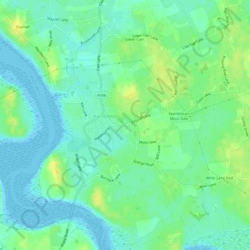
Nom : Carte topographique Hambleton, altitude, relief.
Altitude moyenne : 9 m
Altitude minimum : 0 m
Altitude maximum : 23 m
Autres cartes topographiques
Cliquez sur une carte pour visualiser sa topographie, son altitude et son relief.
Beach Lighthouse
United Kingdom > England > Lancashire > Borough of Wyre > Fleetwood
Altitude moyenne : 3 m