
Carte topographique Hemis Shukpachan
Carte interactive
Cliquez sur la carte pour afficher l’altitude.
À propos de cette carte
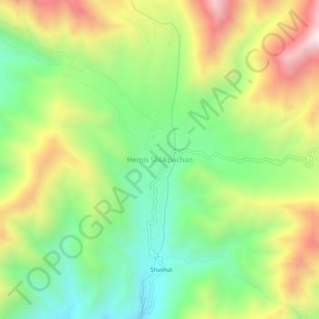
Nom : Carte topographique Hemis Shukpachan, altitude, relief.
Lieu : Hemis Shukpachan, Khalsi tehsil, Leh District, Ladakh, India (34.29591 77.05741 34.33591 77.09741)
Altitude moyenne : 3’818 m
Altitude minimum : 3’437 m
Altitude maximum : 4’361 m
Autres cartes topographiques
Cliquez sur une carte pour visualiser sa topographie, son altitude et son relief.
Tingmosgang
India > Ladakh > Khalsi tehsil > Khaling
Tingmosgang, Khaling, Khalsi tehsil, Leh District, Ladakh, India
Altitude moyenne : 3’410 m