
Carte topographique Antequera
Carte interactive
Cliquez sur la carte pour afficher l’altitude.
À propos de cette carte
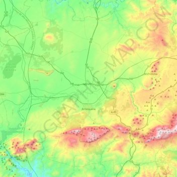
Nom : Carte topographique Antequera, altitude, relief.
Lieu : Antequera, Malaga, Andalusia, Spain (36.89369 -4.82779 37.23108 -4.34693)
Altitude moyenne : 570 m
Altitude minimum : 141 m
Altitude maximum : 1’429 m
In 2011, Antequera had a population of 41,854. It covers an area of 749.34 km2 with a population density of 55.85 inhabitants/km2, and is situated at an altitude of 575 meters. Antequera is the most populous city in the interior of the province and the largest in area. It is the twenty-second largest in Spain. The city is located 45 km from Málaga and 115 km from Córdoba. The cities are connected by a high-speed train and the A-45 motorway. Antequera is 160 km from Seville and 102 km from Granada, which is connected by motorway A-92 and will be connected by the high-speed Transverse Axis Rail in the near future.
Autres cartes topographiques
Cliquez sur une carte pour visualiser sa topographie, son altitude et son relief.
Mataliebres
Spain > Andalusia > Antequera > Mollina
Mataliebres, Mollina, Antequera, Malaga, Andalusia, 29530, Spain
Altitude moyenne : 554 m
Casabermeja
Casabermeja, Antequera, Malaga, Andalusia, 29160, Spain
Altitude moyenne : 595 m