
Carte topographique Kultali
Carte interactive
Cliquez sur la carte pour afficher l’altitude.
À propos de cette carte
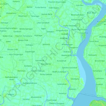
Nom : Carte topographique Kultali, altitude, relief.
Lieu : Kultali, South 24 Parganas District, West Bengal, India (22.00609 88.51788 22.21812 88.63014)
Altitude moyenne : 3 m
Altitude minimum : -2 m
Altitude maximum : 10 m
The Kultali CD block is located at 22°05′12″N 88°35′37″E / 22.0866°N 88.5937°E / 22.0866; 88.5937. It has an average elevation of 7 metres (23 ft).
Autres cartes topographiques
Cliquez sur une carte pour visualiser sa topographie, son altitude et son relief.
Chittaranjan
India > West Bengal > Salanpur
Chittaranjan, Salanpur, Paschim Bardhaman District, West Bengal, 713331, India
Altitude moyenne : 156 m
Dhupguri
Dhupguri, Jalpaiguri District, West Bengal, India
Altitude moyenne : 142 m
Neamatpur
India > West Bengal > Goalpokhar - II
Neamatpur, Goalpokhar - II, Uttar Dinajpur District, West Bengal, India
Altitude moyenne : 40 m
Mandirbazar
Mandirbazar, South 24 Parganas District, West Bengal, 743336, India
Altitude moyenne : 4 m
Ilam Bazar
India > West Bengal > Illambazar
Ilam Bazar, Illambazar, Birbhum District, West Bengal, 731214, India
Altitude moyenne : 58 m
Nabagram
Nabagram, Murshidabad District, West Bengal, India
Altitude moyenne : 24 m
Balughata
India > West Bengal > Haldia
Balughata, Haldia, Purba Medinipur District, West Bengal, 721666, India
Altitude moyenne : 3 m
Sonada
India > West Bengal > Jorebunglow Sukiapokhri
Sonada, Jorebunglow Sukiapokhri, Darjeeling District, West Bengal, 734102, India
Altitude moyenne : 1’797 m
Jorebunglow Sukiapokhri
Jorebunglow Sukiapokhri, Darjeeling District, West Bengal, India
Altitude moyenne : 1’591 m
Sriniketan
India > West Bengal > Bolpur Sriniketan
Sriniketan, Bolpur Sriniketan, Birbhum District, West Bengal, 731235, India
Altitude moyenne : 53 m
Bolpur
India > West Bengal > Bolpur Sriniketan
Bolpur, Bolpur Sriniketan, Birbhum District, West Bengal, India
Altitude moyenne : 50 m
Bolpur Sriniketan
Bolpur Sriniketan, Birbhum District, West Bengal, India
Altitude moyenne : 42 m
Diamond Harbour - II
Diamond Harbour - II, South 24 Parganas District, West Bengal, 743368, India
Altitude moyenne : 3 m
Kalimpong -I
Kalimpong -I, Kalimpong District, West Bengal, India
Altitude moyenne : 824 m
Alipurduar
India > West Bengal > Alipurduar - I
Alipurduar, Alipurduar - I, Alipurduar District, West Bengal, 736121, India
Altitude moyenne : 54 m
Chalsa
India > West Bengal > Matiali
Chalsa, Matiali, Jalpaiguri District, West Bengal, 735206, India
Altitude moyenne : 185 m
Rajpur Sonarpur
India > West Bengal > Sonarpur
Rajpur Sonarpur, Sonarpur, South 24 Parganas District, West Bengal, 700150, India
Altitude moyenne : 4 m
Bhangar - I
Bhangar - I, South 24 Parganas District, West Bengal, 743502, India
Altitude moyenne : 3 m
Jaynagar Majilpur
India > West Bengal > Jaynagar - I
Jaynagar Majilpur, Jaynagar - I, South 24 Parganas District, West Bengal, 743337, India
Altitude moyenne : 5 m
Ghoramara
India > West Bengal > Islampur
Ghoramara, Islampur, Uttar Dinajpur District, West Bengal, 733202, India
Altitude moyenne : 62 m
Paschim Medinipur District
Paschim Medinipur District, West Bengal, India
Altitude moyenne : 34 m
Manteswar
Manteswar, Purba Bardhaman District, West Bengal, India
Altitude moyenne : 16 m
Darjeeling Pulbazar
Darjeeling Pulbazar, Darjeeling District, West Bengal, India
Altitude moyenne : 1’779 m
Mayurakshi
India > West Bengal > Bharatpur - I
Mayurakshi, Bharatpur - I, Murshidabad District, West Bengal, India
Altitude moyenne : 20 m
Bally
India > West Bengal > Bally Jagachha
Bally, Bally Jagachha, Howrah, West Bengal, 712258, India
Altitude moyenne : 6 m
Faridpur Durgapur
Faridpur Durgapur, Paschim Bardhaman, West Bengal, India
Altitude moyenne : 80 m
Siliguri
India > West Bengal > Siliguri Subdivsion
Siliguri, Siliguri Subdivsion, Darjeeling District, West Bengal, India
Altitude moyenne : 121 m
Gangani - The Grand Canyon Of Bengal
India > West Bengal > Garbeta-I
Gangani - The Grand Canyon Of Bengal, Garbeta-I, Paschim Medinipur, West Bengal, 721127, India
Altitude moyenne : 46 m
Jiaganj Azimganj
India > West Bengal > Murshidabad Jiaganj
Jiaganj Azimganj, Murshidabad Jiaganj, Murshidabad, West Bengal, 742123, India
Altitude moyenne : 22 m
Durgapur
India > West Bengal > Faridpur Durgapur
Durgapur, Faridpur Durgapur, Paschim Bardhaman District, West Bengal, 713200, India
Altitude moyenne : 76 m
Bidhannagar
Bidhannagar, North 24 Parganas District, West Bengal, India
Altitude moyenne : 5 m
Sandakphu
India > West Bengal > Darjeeling Pulbazar
Sandakphu, Darjeeling Pulbazar, Darjeeling district, West Bengal, India
Altitude moyenne : 3’285 m
Ashoknagar Kalyangarh
India > West Bengal > Habra - II
Ashoknagar Kalyangarh, Habra - II, West Bengal, 743222, India
Altitude moyenne : 7 m
Shantipur
India > West Bengal > Santipur
Shantipur, Santipur, Nadia, West Bengal, 741404, India
Altitude moyenne : 11 m
Jhalda - I
Jhalda - I, Puruliya, West Bengal, 723202, India
Altitude moyenne : 312 m
Cooch Behar
India > West Bengal > Cooch Behar
Cooch Behar, Kochbihar, West Bengal, India
Altitude moyenne : 41 m
Arambagh
India > West Bengal > Arambag
Arambagh, Arambag, Hooghly District, West Bengal, 712600, India
Altitude moyenne : 17 m
Bardhaman
India > West Bengal > Burdwan - I
Bardhaman, Burdwan - I, Purba Bardhaman District, West Bengal, India
Altitude moyenne : 31 m
Mandarmani
India > West Bengal > Ramnagar-II
Mandarmani, Ramnagar-II, Purba Medinipur, West Bengal, India
Altitude moyenne : 2 m