
Faire un don
Équipez-vous pour votre prochaine aventure :
En tant que Partenaire Amazon, ce site perçoit une commission sur les achats éligibles sans surcoût pour vous.
Carte topographique Knighton
Cliquez sur la carte pour afficher l’altitude.
Faire un don
Équipez-vous pour votre prochaine aventure :
En tant que Partenaire Amazon, ce site perçoit une commission sur les achats éligibles sans surcoût pour vous.
Knighton
The town became a borough in 1203, with a charter permitting a weekly market and annual fair. The presence of two castles within a comparatively small town suggests that one (the earlier motte and bailey sited atop the town) went out of use before the establishment of the second (the motte with no bailey at Bryn y Castell). As Knighton Castle was captured and destroyed by Llewelyn ap Gruffyd in 1262, it seems likely that the second, later castle at Bryn y Castell was undertaken after that and was likely sited on lower ground so as to guard the crossing point of the River Teme. Bryn y Castell, as the one surviving castle in Knighton by then, was besieged by Owain Glyndŵr in 1402 and destroyed along with much of the town. The major battle of the rebellion was fought in the same year at Pilleth (Welsh: Bryn Glas) 3 miles (5 km), south of the town. Though documents pertaining to the defence of Knighton during the Glyndwr rebellion state that Knighton had stout and defensible walls, no historical, archaeological or topographic evidence for a town wall, even of timber, has been found. So it is thought more likely that the statement referred to the castle walls, rather than the town.
Faire un don
Équipez-vous pour votre prochaine aventure :
En tant que Partenaire Amazon, ce site perçoit une commission sur les achats éligibles sans surcoût pour vous.
À propos de cette carte
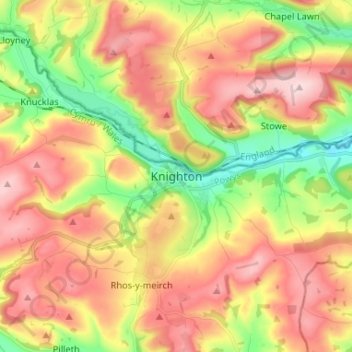
Nom : Carte topographique Knighton, altitude, relief.
Lieu : Knighton, Powys, Wales, LD7 1BS, United Kingdom (52.30435 -3.08956 52.38435 -3.00956)
Altitude moyenne : 295 m
Altitude minimum : 147 m
Altitude maximum : 437 m
Faire un don
Équipez-vous pour votre prochaine aventure :
En tant que Partenaire Amazon, ce site perçoit une commission sur les achats éligibles sans surcoût pour vous.
Autres cartes topographiques
Cliquez sur une carte pour visualiser sa topographie, son altitude et son relief.
Brecon Beacons National Park
United Kingdom > Wales > Powys
Brecon Beacons National Park, officially named Bannau Brycheiniog National Park (Welsh pronunciation), is a national park in Wales. It is named after the Brecon Beacons (Welsh: Bannau Brycheiniog), the mountain range at its centre. The national park includes the highest mountain in South Wales, Pen y Fan,…
Altitude moyenne : 270 m
Faire un don
Équipez-vous pour votre prochaine aventure :
En tant que Partenaire Amazon, ce site perçoit une commission sur les achats éligibles sans surcoût pour vous.
Faire un don
Équipez-vous pour votre prochaine aventure :
En tant que Partenaire Amazon, ce site perçoit une commission sur les achats éligibles sans surcoût pour vous.
Faire un don
Équipez-vous pour votre prochaine aventure :
En tant que Partenaire Amazon, ce site perçoit une commission sur les achats éligibles sans surcoût pour vous.
Faire un don
Équipez-vous pour votre prochaine aventure :
En tant que Partenaire Amazon, ce site perçoit une commission sur les achats éligibles sans surcoût pour vous.
Llangorse Lake
United Kingdom > Wales > Powys > Llangors
The lake is a Site of Special Scientific Interest (SSSI) and has long been regarded as a place where fish and birds are found in unusually high numbers. Gerald of Wales (Giraldus Cambrensis) mentioned the abundance of waterfowl in his topographical work, The Description of Wales in the 12th century. It is a…
Altitude moyenne : 177 m
Faire un don
Équipez-vous pour votre prochaine aventure :
En tant que Partenaire Amazon, ce site perçoit une commission sur les achats éligibles sans surcoût pour vous.
Faire un don
Équipez-vous pour votre prochaine aventure :
En tant que Partenaire Amazon, ce site perçoit une commission sur les achats éligibles sans surcoût pour vous.
Craig Cerrig Gleisiad a Fan Frynych National Nature Reserve
United Kingdom > Wales > Powys
Altitude moyenne : 473 m
River Severn
United Kingdom > Wales > Powys > Welshpool
The River Severn (Welsh: Afon Hafren, pronounced [ˈavɔn ˈhavrɛn]), at 220 miles (354 km) long, is the longest river in Great Britain. It is also the river with the most voluminous flow of water by far in all of England and Wales, with an average flow rate of 107 m3/s (3,800 cu ft/s) at Apperley,…
Altitude moyenne : 92 m
Faire un don
Équipez-vous pour votre prochaine aventure :
En tant que Partenaire Amazon, ce site perçoit une commission sur les achats éligibles sans surcoût pour vous.
Grwyne Fawr Reservoir
United Kingdom > Wales > Powys
By the end of the 19th-century there were serious water shortages in the western parts of the historic county of Monmouthshire. The area had seen a massive population increase as a result of the steel and coal industries but the supply of water to the area was complicated due to its high altitude. A site for a…
Altitude moyenne : 619 m
Faire un don
Équipez-vous pour votre prochaine aventure :
En tant que Partenaire Amazon, ce site perçoit une commission sur les achats éligibles sans surcoût pour vous.
Faire un don
Équipez-vous pour votre prochaine aventure :
En tant que Partenaire Amazon, ce site perçoit une commission sur les achats éligibles sans surcoût pour vous.
Faire un don
Équipez-vous pour votre prochaine aventure :
En tant que Partenaire Amazon, ce site perçoit une commission sur les achats éligibles sans surcoût pour vous.
Faire un don
Équipez-vous pour votre prochaine aventure :
En tant que Partenaire Amazon, ce site perçoit une commission sur les achats éligibles sans surcoût pour vous.
Brecon Beacons National Park
United Kingdom > Wales > Powys
Brecon Beacons National Park, officially named Bannau Brycheiniog National Park (Welsh pronunciation), is a national park in Wales. It is named after the Brecon Beacons (Welsh: Bannau Brycheiniog), the mountain range at its centre. The national park includes the highest mountain in South Wales, Pen y Fan,…
Altitude moyenne : 270 m
Faire un don
Équipez-vous pour votre prochaine aventure :
En tant que Partenaire Amazon, ce site perçoit une commission sur les achats éligibles sans surcoût pour vous.