
Carte topographique Rothley
Cliquez sur la carte pour afficher l’altitude.
À propos de cette carte
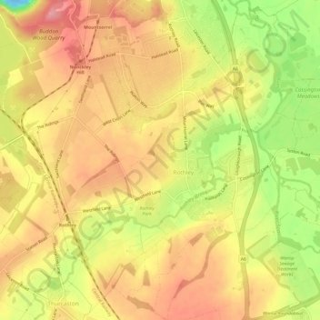
Nom : Carte topographique Rothley, altitude, relief.
Lieu : Rothley, Charnwood, Leicestershire, England, United Kingdom (52.69276 -1.17440 52.72932 -1.11832)
Altitude moyenne : 64 m
Altitude minimum : -22 m
Altitude maximum : 102 m
Autres cartes topographiques
Cliquez sur une carte pour visualiser sa topographie, son altitude et son relief.
Bradgate Park
United Kingdom > England > Leicestershire > Charnwood > Newtown Linford
Overlying the Beacon Hill Formation, but found a little further down the hillside to the south, are the Bradgate Formation beds, the most notable of which is the Sliding Stone Slump Breccia rocks. Forming a line of crags below Old John, these are laminated mudstones, with layers of sandstone, mainly of…
Altitude moyenne : 126 m
Watermead Country Park
United Kingdom > England > Leicestershire > Charnwood > Birstall
Altitude moyenne : 59 m
Top Town Plantation
United Kingdom > England > Leicestershire > Charnwood > Walton on the Wolds
Altitude moyenne : 85 m
Moat Hill Spinney
United Kingdom > England > Leicestershire > Charnwood > Cotes
Altitude moyenne : 50 m
Lea Wood
United Kingdom > England > Leicestershire > Charnwood > Newtown Linford
Altitude moyenne : 170 m
Old John
United Kingdom > England > Leicestershire > Charnwood > Newtown Linford
Altitude moyenne : 143 m
Six Hills
United Kingdom > England > Leicestershire > Charnwood > Burton on the Wolds
Altitude moyenne : 128 m
Swithland Wood
United Kingdom > England > Leicestershire > Charnwood > Swithland
Altitude moyenne : 107 m
Beacon Hill Country Park
United Kingdom > England > Leicestershire > Charnwood > Woodhouse Eaves
Altitude moyenne : 164 m