
Carte topographique Trumra Rock
Carte interactive
Cliquez sur la carte pour afficher l’altitude.
À propos de cette carte
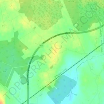
Nom : Carte topographique Trumra Rock, altitude, relief.
Altitude moyenne : 105 m
Altitude minimum : 89 m
Altitude maximum : 125 m
Autres cartes topographiques
Cliquez sur une carte pour visualiser sa topographie, son altitude et son relief.
Stradbally
Stradbally, Stradbally ED, The Municipal District of Graiguecullen — Portarlington, County Laois, Leinster, Ireland
Altitude moyenne : 92 m
Mountmellick
Mountmellick, The Municipal District of Borris-in-Ossory — Mountmellick, County Laois, Leinster, Ireland
Altitude moyenne : 76 m
Burke's Cross
Burke's Cross, Lacka ED, The Municipal District of Borris-in-Ossory — Mountmellick, County Laois, Leinster, Ireland
Altitude moyenne : 195 m
Timahoe
Timahoe, The Municipal District of Graiguecullen — Portarlington, County Laois, Leinster, R32 Y09T, Ireland
Altitude moyenne : 146 m
The Municipal District of Portlaoise
The Municipal District of Portlaoise, County Laois, Leinster, Ireland
Altitude moyenne : 138 m
The Municipal District of Graiguecullen — Portarlington
The Municipal District of Graiguecullen — Portarlington, County Laois, Leinster, Ireland
Altitude moyenne : 113 m
Killadooley
Killadooley, Ballybrophy ED, The Municipal District of Borris-in-Ossory — Mountmellick, County Laois, Leinster, Ireland
Altitude moyenne : 122 m