
Carte topographique Luling
Carte interactive
Cliquez sur la carte pour afficher l’altitude.
À propos de cette carte
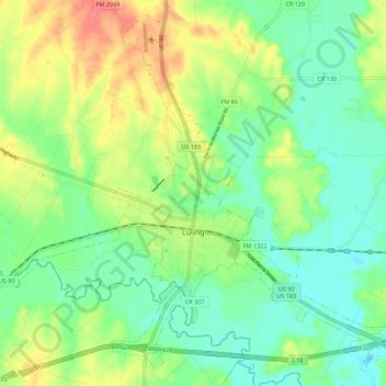
Nom : Carte topographique Luling, altitude, relief.
Lieu : Luling, Caldwell County, Texas, 78468, United States (29.64527 -97.70030 29.73462 -97.58941)
Altitude moyenne : 121 m
Altitude minimum : 99 m
Altitude maximum : 156 m
Autres cartes topographiques
Cliquez sur une carte pour visualiser sa topographie, son altitude et son relief.
Dale
United States > Texas > Caldwell County
Dale, Caldwell County, Texas, 78616, United States
Altitude moyenne : 155 m
Uhland
United States > Texas > Caldwell County
Uhland, Caldwell County, Texas, United States
Altitude moyenne : 180 m
Lockhart
United States > Texas > Caldwell County
Lockhart, Caldwell County, Texas, 78644, United States
Altitude moyenne : 156 m
Fentress
United States > Texas > Caldwell County > Fentress
Fentress, Caldwell County, Texas, 78922, United States
Altitude moyenne : 139 m
Lockhart
United States > Texas > Caldwell County > Lockhart > Lockhart
Lockhart, Caldwell County, Texas, 78644, United States
Altitude moyenne : 157 m