
Carte topographique Rio Grande
Carte interactive
Cliquez sur la carte pour afficher l’altitude.
À propos de cette carte
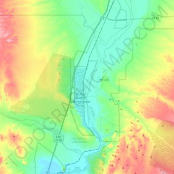
Nom : Carte topographique Rio Grande, altitude, relief.
Lieu : Rio Grande, Socorro County, New Mexico, United States (34.25482 -106.88750 34.43727 -106.79837)
Altitude moyenne : 1’502 m
Altitude minimum : 1’419 m
Altitude maximum : 1’652 m
The Rio Grande rises in high mountains and flows for much of its length at high elevation; Albuquerque is 5,312 feet (1,619 m), and El Paso 3,762 feet (1,147 m) above sea level. In New Mexico, the river flows through the Rio Grande rift from one sediment-filled basin to another, cutting canyons between the basins and supporting a fragile bosque ecosystem on its flood plain. From El Paso eastward, the river flows through desert. Although irrigated agriculture exists throughout most of its stretch, it is particularly extensive in the subtropical Lower Rio Grande Valley. The river ends in a small, sandy delta at the Gulf of Mexico. During portions of 2001 and 2002, the mouth of the Rio Grande was blocked by a sandbar. In the fall of 2003, the sandbar was cleared by high river flows around 7,063 cubic feet per second (200 m3/s).
Autres cartes topographiques
Cliquez sur une carte pour visualiser sa topographie, son altitude et son relief.
Socorro
United States > New Mexico > Socorro County
Socorro, Socorro County, New Mexico, United States
Altitude moyenne : 1’433 m