
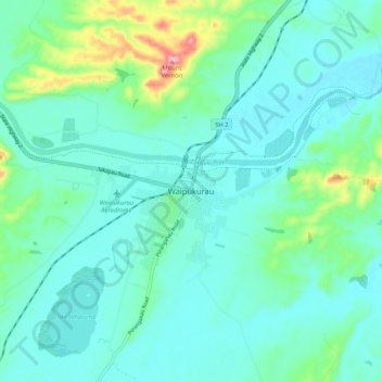
Carte topographique Waipukurau
Carte interactive
Cliquez sur la carte pour afficher l’altitude.
À propos de cette carte
Nom : Carte topographique Waipukurau, altitude, relief.
Altitude moyenne : 153 m
Altitude minimum : 118 m
Altitude maximum : 305 m
Autres cartes topographiques
Cliquez sur une carte pour visualiser sa topographie, son altitude et son relief.
Waipawa Hill
New Zealand > Hawke's Bay > Central Hawke's Bay District
Waipawa Hill, Central Hawke's Bay District, Hawke's Bay, 4210, New Zealand
Altitude moyenne : 253 m
Kairakau Beach
New Zealand > Hawke's Bay > Central Hawke's Bay District
Kairakau Beach, Central Hawke's Bay District, Hawke's Bay, New Zealand
Altitude moyenne : 46 m
Otane
New Zealand > Hawke's Bay > Central Hawke's Bay District
Otane, Central Hawke's Bay District, Hawke's Bay, 4202, New Zealand
Altitude moyenne : 120 m
Ongaonga
New Zealand > Hawke's Bay > Central Hawke's Bay District
Ongaonga, Central Hawke's Bay District, Hawke's Bay, New Zealand
Altitude moyenne : 206 m