
Carte topographique Wachtum
Carte interactive
Cliquez sur la carte pour afficher l’altitude.
À propos de cette carte
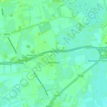
Nom : Carte topographique Wachtum, altitude, relief.
Lieu : Wachtum, Coevorden, Drenthe, Nederland (52.71207 6.70857 52.74273 6.78152)
Altitude moyenne : 13 m
Altitude minimum : 9 m
Altitude maximum : 19 m
Autres cartes topographiques
Cliquez sur une carte pour visualiser sa topographie, son altitude et son relief.
Steenwijksmoer
Nederland > Drenthe > Coevorden
Steenwijksmoer, Coevorden, Drenthe, Nederland, 7741 PC, Nederland
Altitude moyenne : 11 m
Veenhuizen
Nederland > Drenthe > Coevorden > Dalen
Veenhuizen, Dalen, Coevorden, Drenthe, Nederland, 7751 SR, Nederland
Altitude moyenne : 12 m
Oosterhesselen
Nederland > Drenthe > Coevorden
Oosterhesselen, Coevorden, Drenthe, Nederland
Altitude moyenne : 15 m
Noord-Sleen
Nederland > Drenthe > Coevorden
Noord-Sleen, Coevorden, Drenthe, Nederland
Altitude moyenne : 18 m
Schoonoord
Nederland > Drenthe > Coevorden
Schoonoord, Coevorden, Drenthe, Nederland
Altitude moyenne : 19 m
't Haantje
Nederland > Drenthe > Coevorden
't Haantje, Coevorden, Drenthe, Nederland
Altitude moyenne : 18 m
Wezuperbrug
Nederland > Drenthe > Coevorden
Wezuperbrug, Coevorden, Drenthe, Nederland
Altitude moyenne : 20 m
De Klencke
Nederland > Drenthe > Coevorden
De Klencke, Klenkerweg, Oosterhesselen, Coevorden, Drenthe, Nederland, 7861TC, Nederland
Altitude moyenne : 15 m