
Carte topographique Arghakhanchi
Carte interactive
Cliquez sur la carte pour afficher l’altitude.
À propos de cette carte
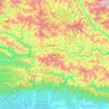
Nom : Carte topographique Arghakhanchi, altitude, relief.
Lieu : Arghakhanchi, Lumbini Province, 32700, Nepal (27.74981 82.74585 28.11396 83.33071)
Altitude moyenne : 962 m
Altitude minimum : 112 m
Altitude maximum : 2’736 m
Arghakhanchi lies between 27'45"N and 28'6"N latitude, and 80'45"E to 83'23"E longitude. It covers 1,193 km2. The altitude of the district varies from 305 to 2515 meter above the sea level. 68% of the district is in the mountainous Mahabharat Range and the rest is in the Siwalik Hills. Elevations range from 305 to 2575 m above sea level and about 40% of the total area is forested.
Autres cartes topographiques
Cliquez sur une carte pour visualiser sa topographie, son altitude et son relief.
Nawalparasi West / Bardaghat Susta
Nepal > Lumbini Province > Nawalparasi W
Nawalparasi West / Bardaghat Susta, Nawalparasi W, Lumbini Province, Nepal
Altitude moyenne : 263 m
Kapilbastu
Nepal > Lumbini Province > Kapilvastu
Kapilbastu, Kapilvastu, Lumbini Province, Nepal
Altitude moyenne : 105 m
Tilottama
Nepal > Lumbini Province > Rupandehi
Tilottama, Rupandehi, Lumbini Province, 32903, Nepal
Altitude moyenne : 130 m
Hyang
Nepal > Lumbini Province > Rolpa
Hyang, Triveni-02, Tribeni, Rolpa, Lumbini Province, Nepal
Altitude moyenne : 1’462 m
Bhaba
Nepal > Lumbini Province > Rolpa
Bhaba, Sunchhahari-03, Sunchhahari, Rolpa, Lumbini Province, Nepal
Altitude moyenne : 2’423 m
Satyawati
Nepal > Lumbini Province > Gulmi
Satyawati, Gulmi, Lumbini Province, Nepal
Altitude moyenne : 1’261 m
Putha Uttarganga
Nepal > Lumbini Province > Eastern Rukum
Putha Uttarganga, Eastern Rukum, Lumbini Province, Nepal
Altitude moyenne : 2’899 m
Bagnaskali
Nepal > Lumbini Province > Palpa
Bagnaskali, Palpa, Lumbini Province, 32500, Nepal
Altitude moyenne : 862 m