
Carte topographique Schaumburg
Carte interactive
Cliquez sur la carte pour afficher l’altitude.
À propos de cette carte
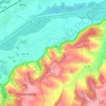
Nom : Carte topographique Schaumburg, altitude, relief.
Lieu : Schaumburg, Frauenberg, Landshut, Bayern, 84036, Deutschland (48.56046 12.23751 48.60046 12.27751)
Altitude moyenne : 419 m
Altitude minimum : 367 m
Altitude maximum : 496 m
Autres cartes topographiques
Cliquez sur une carte pour visualiser sa topographie, son altitude et son relief.
Burg Trausnitz
Deutschland > Bayern > Landshut
Burg Trausnitz, 168, Burg Trausnitz, Berg, Landshut, Bayern, 84036, Deutschland
Altitude moyenne : 426 m
Kranzed
Deutschland > Bayern > Landshut
Kranzed, Schönbrunn, Landshut, Bayern, 84036, Deutschland
Altitude moyenne : 429 m
Schweinbach
Deutschland > Bayern > Landshut
Schweinbach, Landshut, Bayern, 84028, Deutschland
Altitude moyenne : 404 m