
Carte topographique Kanhangad
Carte interactive
Cliquez sur la carte pour afficher l’altitude.
À propos de cette carte
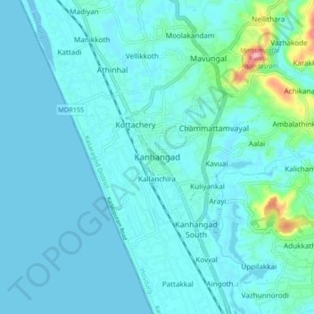
Nom : Carte topographique Kanhangad, altitude, relief.
Lieu : Kanhangad, Hosdurg, Kasaragod District, Kerala, 671315, India (12.27356 75.05246 12.35356 75.13246)
Altitude moyenne : 18 m
Altitude minimum : -6 m
Altitude maximum : 169 m
Kanhangad lies at 12°18′0″N 75°5.4′0″E in the geographic map of Kasaragod. It is a coastal town which has a varied topography with plain areas in the centre of the city. The landscape is dominated by the characteristic coconut palms accompanying rolling hills and streams flowing into the sea. In the East, there are hilly areas of Madikai . The western region has powdered sand and a mix of laterite and alluvial soil in the areas between. The hilly areas typically consists of red sand.
Autres cartes topographiques
Cliquez sur une carte pour visualiser sa topographie, son altitude et son relief.
Charakadvu
India > Kerala > Hosdurg > Karuvakkode
Charakadvu, Karuvakkode, Hosdurg, Kasaragod District, Kerala, 671316, India
Altitude moyenne : 25 m
Kottakkani
Kottakkani, Hosdurg, Kasaragod District, Kerala, 671316, India
Altitude moyenne : 23 m
Beericheri
Beericheri, Hosdurg, Kasaragod District, Kerala, 671311, India
Altitude moyenne : 7 m
Vellacheri
India > Kerala > Hosdurg > Chunda
Vellacheri, Chunda, Hosdurg, Kasaragod District, Kerala, India
Altitude moyenne : 70 m
Kanhangad
India > Kerala > Hosdurg > Muriyanavi
Kanhangad, Muriyanavi, Hosdurg, Kasaragod district, Kerala, 671315, India
Altitude moyenne : 19 m
Ambalathara
India > Kerala > Hosdurg > Gurupuram
Ambalathara, Gurupuram, Hosdurg, Kasaragod district, Kerala, India
Altitude moyenne : 62 m