
Faire un don
Équipez-vous pour votre prochaine aventure :
En tant que Partenaire Amazon, ce site perçoit une commission sur les achats éligibles sans surcoût pour vous.
Carte topographique Tipaturu
Cliquez sur la carte pour afficher l’altitude.
Faire un don
Équipez-vous pour votre prochaine aventure :
En tant que Partenaire Amazon, ce site perçoit une commission sur les achats éligibles sans surcoût pour vous.
Tipaturu
Tiptur has been surrounded by from the west side Arsikere and channarayapatna. from the east side Chikkanayakana halli, Gubbi, Turuvekere. Tiptur is approximately 73 km (45 mi) west of Tumkur along National Highway 206 (now renumbered as National Highway 48). It is at a distance of 140 km (87 mi) northwest from the state capital, Bangalore. It lies on the Bangalore-Miraj railway line. Tiptur has an average elevation of 861 metres (2,825 ft). The average temperature in summer is 34 °C (93 °F) and in winter is 20 °C (68 °F).
Faire un don
Équipez-vous pour votre prochaine aventure :
En tant que Partenaire Amazon, ce site perçoit une commission sur les achats éligibles sans surcoût pour vous.
À propos de cette carte
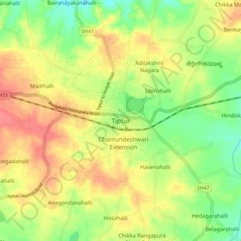
Nom : Carte topographique Tipaturu, altitude, relief.
Lieu : Tipaturu, Tipaturu taluk, Tumakuru, Karnataka, 572200, India (13.21858 76.43377 13.29858 76.51377)
Altitude moyenne : 855 m
Altitude minimum : 823 m
Altitude maximum : 886 m
Faire un don
Équipez-vous pour votre prochaine aventure :
En tant que Partenaire Amazon, ce site perçoit une commission sur les achats éligibles sans surcoût pour vous.