
Carte topographique Newkirk
Carte interactive
Cliquez sur la carte pour afficher l’altitude.
Newkirk
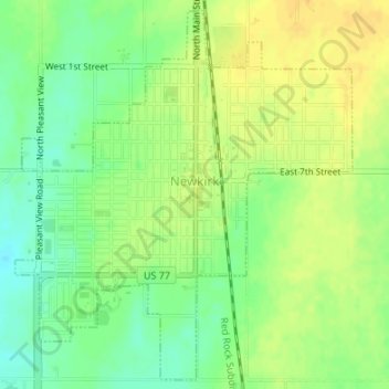
Newkirk's elevation is 1,152 feet (351 m). It is on mostly flat terrain with no large watercourses nearby, and at the boundary between two ecoregions: the Central Great Plains and the Flint Hills. West of the town on the Great Plains, the countryside is rich agricultural land, especially for wheat, soybeans, and cattle. East of town, the Flint Hills' terrain is more rugged and rocky and is primarily used for cattle ranching. Natural vegetation is mostly prairie, but stream valleys often have forests of cottonwood, oak, elm, ash, pecan, sycamore, and other species. Scrub oak and red cedar dot hillsides. Wildlife is abundant, including whitetail deer, turkey, bobwhite quail, coyote, bobcat, and waterfowl. A cougar attack on a person seven miles (11 km) east of Newkirk was reported in 2002.
À propos de cette carte
Nom : Carte topographique Newkirk, altitude, relief.
Lieu : Newkirk, Kay County, Oklahoma, 74647, United States (36.86857 -97.06925 36.89420 -97.04001)
Altitude moyenne : 350 m
Altitude minimum : 335 m
Altitude maximum : 361 m
Autres cartes topographiques
Cliquez sur une carte pour visualiser sa topographie, son altitude et son relief.