Géolocaliser

Carte topographique River Nith

Cliquez sur la carte pour afficher l’altitude.

À propos de cette carte

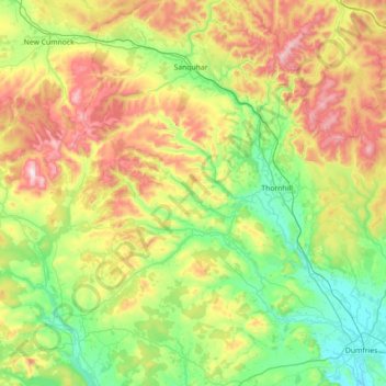
Nom : Carte topographique River Nith, altitude, relief.

Lieu : River Nith, Dumfries and Galloway, Scotland, United Kingdom (54.97786 -4.31062 55.40158 -3.56998)

Altitude moyenne : 231 m

Altitude minimum : 0 m

Altitude maximum : 791 m

Autres cartes topographiques

Cliquez sur une carte pour visualiser sa topographie, son altitude et son relief.

Annan

United Kingdom > Scotland > Dumfries and Galloway

Altitude moyenne : 25 m

Moffat

United Kingdom > Scotland > Dumfries and Galloway

Altitude moyenne : 225 m

Moniaive

United Kingdom > Scotland > Dumfries and Galloway

Altitude moyenne : 179 m

Gretna

United Kingdom > Scotland > Dumfries and Galloway

Altitude moyenne : 19 m

Caldons

United Kingdom > Scotland > Dumfries and Galloway

Altitude moyenne : 208 m

Merci de soutenir ce site ❤️
Faire un don

Équipez-vous pour votre prochaine aventure :

En tant que Partenaire Amazon, ce site perçoit une commission sur les achats éligibles sans surcoût pour vous.

Eskdalemuir

United Kingdom > Scotland > Dumfries and Galloway

In spite of it being located inland, the dull and wet nature of the climate due to the elevation leads to chilly summers that are colder than more northerly locations such as Glasgow and Edinburgh. The inland nature of the climate is more manifest during winter months with frosts being common, and the average…

Altitude moyenne : 246 m

Langholm

United Kingdom > Scotland > Dumfries and Galloway

Altitude moyenne : 185 m

Ley Hill

United Kingdom > Scotland > Dumfries and Galloway

Altitude moyenne : 214 m

Ae

United Kingdom > Scotland > Dumfries and Galloway

Altitude moyenne : 195 m

Tynron

United Kingdom > Scotland > Dumfries and Galloway > Tynron

Altitude moyenne : 194 m

Boreland

United Kingdom > Scotland > Dumfries and Galloway

Altitude moyenne : 194 m

Borgue

United Kingdom > Scotland > Dumfries and Galloway

Altitude moyenne : 50 m

Beattock

United Kingdom > Scotland > Dumfries and Galloway

Altitude moyenne : 144 m

Fingland

United Kingdom > Scotland > Dumfries and Galloway

Altitude moyenne : 206 m

Arkleton

United Kingdom > Scotland > Dumfries and Galloway

Altitude moyenne : 236 m

Courance

United Kingdom > Scotland > Dumfries and Galloway

Altitude moyenne : 113 m

Corsock

United Kingdom > Scotland > Dumfries and Galloway

Altitude moyenne : 156 m

Bran Rig

United Kingdom > Scotland > Dumfries and Galloway

Altitude moyenne : 196 m

Milton

United Kingdom > Scotland > Dumfries and Galloway

Altitude moyenne : 123 m

Mennock

United Kingdom > Scotland > Dumfries and Galloway

Altitude moyenne : 193 m

Harelaw

United Kingdom > Scotland > Dumfries and Galloway

Altitude moyenne : 108 m

Merrick

United Kingdom > Scotland > Dumfries and Galloway

The Merrick, or simply Merrick (Scottish Gaelic: A' Mhearag), is a mountain in the Range of the Awful Hand, a sub-range of the Galloway Hills range, part of the Southern Uplands of Scotland. The summit elevation is 843 metres (2,766 feet), making it the highest mountain in the Southern Uplands and southern…

Altitude moyenne : 591 m

Équipez-vous pour votre prochaine aventure :

🗺️Cartes de randonnée - Le support papier indispensable en complément du numérique
🕶️Cordon pour lunettes - Ne perdez plus vos lunettes lors de vos mouvements brusques
🚴Sacs d’hydratation - Hydratation en mouvement
🪑Siège de randonnée pliable - Le confort d'une pause assise sans le poids encombrant
📍GPS de randonnée - Navigation précise hors réseau

En tant que Partenaire Amazon, ce site perçoit une commission sur les achats éligibles sans surcoût pour vous.