
Carte topographique Krasnoyarsk
Carte interactive
Cliquez sur la carte pour afficher l’altitude.
À propos de cette carte
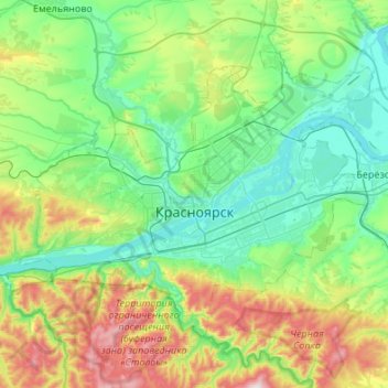
Nom : Carte topographique Krasnoyarsk, altitude, relief.
Altitude moyenne : 285 m
Altitude minimum : 118 m
Altitude maximum : 792 m
The river Yenisei flows from west to east through the city. Due to the Krasnoyarsk hydroelectric dam 32 km (20 mi) upstream, the Yenisei never freezes in winter and never exceeds +14 °C (57 °F) in summer through the city. Near the city center, its elevation is 136 m (446 ft) above sea level. There are several islands in the river, the largest of which are Tatyshev and Otdyha Isles, used mainly for recreation.
Autres cartes topographiques
Cliquez sur une carte pour visualiser sa topographie, son altitude et son relief.
Krasnoyarsk
Russia > Krasnoyarsk Krai > Krasnoyarsk Urban Okrug > Krasnoyarsk
Krasnoyarsk, Krasnoyarsk Urban Okrug, Krasnoyarsk Krai, Siberian Federal District, 660017, Russia
Altitude moyenne : 299 m