
Carte topographique Nevasa
Cliquez sur la carte pour afficher l’altitude.
À propos de cette carte
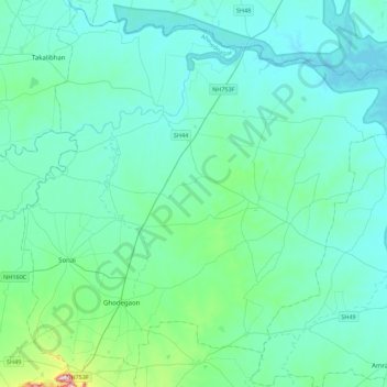
Nom : Carte topographique Nevasa, altitude, relief.
Lieu : Nevasa, Ahmednagar District, India (19.26772 74.76665 19.66549 75.20706)
Altitude moyenne : 501 m
Altitude minimum : 457 m
Altitude maximum : 839 m
Autres cartes topographiques
Cliquez sur une carte pour visualiser sa topographie, son altitude et son relief.
Kakinada
India > Andhra Pradesh > Kakinada Urban
Kakinada is located at 16°56′N 82°13′E / 16.93°N 82.22°E / 16.93; 82.22, with the 82-degrees east longitude passing through the city. The city has an average elevation of 2 meters (6.6 feet), and several areas lie below sea level.
Altitude moyenne : 7 m
Vadodara
India > Gujarat > Vadodara Rural Taluka
Vadodara is located at 22°18′N 73°11′E / 22.30°N 73.19°E / 22.30; 73.19 in western India at an elevation of 39 metres (128 ft). It is the tenth-largest city in India with an area of 400 square kilometres (150 sq mi) and a population of 3.5 million, according to the 2010–11 census. The city…
Altitude moyenne : 36 m
Chennai
Chennai is located on the south–eastern coast of India in the north–eastern part of Tamil Nadu on a flat coastal plain known as the Eastern Coastal Plains. Its average elevation is around 6.7 metres (22 ft), and its highest point is 60 m (200 ft). Chennai is 2,184 kilometres (1,357 mi) south of Delhi,…
Altitude moyenne : 7 m
Maharashtra
Maharashtra is the third largest state by area in India. The Western Ghats better known as Sahyadri, are a hilly range running parallel to the coast, at an average elevation of 1,200 metres (4,000 ft). Kalsubai, a peak in the Sahyadris, near Nashik city is the highest elevated point in Maharashtra. To the west…
Altitude moyenne : 478 m
Bhubaneshwar
India > Odisha > Bhubaneswar (M.Corp.)
Bhubaneswar is in Khordha district of Odisha. It is in the eastern coastal plains, along the axis of the Eastern Ghats mountains. The city has an average altitude of 45 m (148 ft) above sea level. It lies southwest of the Mahanadi River that forms the northern boundary of Bhubaneswar metropolitan area, within…
Altitude moyenne : 30 m
Navi Mumbai
India > Maharashtra > Thane > Navi Mumbai
Navi Mumbai (Marathi pronunciation: , also known by its former name New Bombay), is a planned city off the west coast of the Indian state of Maharashtra in Konkan division. The city is divided into two parts, North Navi Mumbai and South Navi Mumbai, for the individual development of Panvel Mega City, which…
Altitude moyenne : 30 m
Kolhapur
India > Maharashtra > Karvir
Kolhapur is an inland city located in south-west Maharashtra state, 373 km (232 mi) south of Mumbai and 228 km (142 mi) south of Pune, 615 km (382 mi) north-west of Bengaluru and 530 km (330 mi) west of Hyderabad. Within Maharashtra, Kolhapur's nearest cities and towns are Ichalkaranji 27 km (17 mi), Kodoli 35…
Altitude moyenne : 592 m
Western Ghats
The range starts near south of the Tapti river and runs approximately 1,600 km (990 mi) through the states of Gujarat, Maharashtra, Karnataka, Goa, Kerala and Tamil Nadu ending at Marunthuvazh Malai, Swamithope near the southern tip of India. These hills cover 160,000 km2 (62,000 sq mi) and form the catchment…
Altitude moyenne : 2’225 m
Mussoorie
India > Uttarakhand > Dehradun
Mussoorie is at an average altitude of 2,005 metres (6,578 ft). To the northeast are the Himalayan snow ranges, and to the south, the Doon Valley and Shiwalik ranges. The second highest point is the original Lal Tibba in Landour, with a height of over 2,275 m (7,464 ft). Mussoorie is popularly known as The…
Altitude moyenne : 1’594 m
Mysuru
India > Karnataka > Mysuru taluk
Mysore (/maɪˈsɔːr/ (listen)), officially Mysuru ([ˈmaɪˈsuːɾu] (listen)), is a city in the southern part of the state of Karnataka, India. Mysore city is geographically located between 12° 18′ 26″ north latitude and 76° 38′ 59″ east longitude. It is located at an altitude of 770 m (2,530 ft)…
Altitude moyenne : 727 m
Srinagar
India > Jammu and Kashmir > Srinagar (South)
Under the Köppen climate classification, Srinagar has a four-season humid subtropical climate (Cfa) with hot summers and cool winters. The valley is surrounded by the Himalayas on all sides. Due to influence from Himalayan rain shadow and western disturbances, Srinagar has year-round precipitation; the spring…
Altitude moyenne : 1’805 m
Ranchi
Ranchi lies at 23°22′N 85°20′E / 23.36°N 85.33°E / 23.36; 85.33 near to the Tropic of Cancer. The city covers an area of 175 km2 (68 sq mi) and its average elevation is 651 m above sea level. Ranchi is located in the southern part of the Chota Nagpur plateau, which is the eastern section of…
Altitude moyenne : 648 m
Jammu
India > Jammu and Kashmir > Jammu
Jammu is located at 32°44′N 74°52′E / 32.73°N 74.87°E / 32.73; 74.87. It has an average elevation of 300 m (980 ft). Jammu city lies at uneven ridges of low heights at the Shivalik hills. It is surrounded by the Shivalik range to the north, east, and southeast while the Trikuta Range surrounds…
Altitude moyenne : 367 m
Dwarka
India > Gujarat > Okhamandal Taluka
Considered a holy city, Dwarka is well known for its temples and as a pilgrimage centre for Hindus. The Dwarakadhisa Temple, also called Jagat Mandir, located in the heart of Dwarka, is a Vaishnava temple. It was built by Raja Jagat Singh Rathore, hence it is called Jagat Mandir. The temple, facing west, is at…
Altitude moyenne : 3 m
Madurai
India > Tamil Nadu > Madurai
Madurai is located at 9°56′N 78°07′E / 9.93°N 78.12°E / 9.93; 78.12. It has an average elevation of 101 metres. The city of Madurai lies on the flat and fertile plain of the river Vaigai, which runs in the northwest-southeast direction through the city, dividing it into two almost equal…
Altitude moyenne : 138 m
Mumbai
Mumbai lies at the mouth of the Ulhas River on the western coast of India, in the coastal region known as the Konkan. It sits on Salsette Island (Sashti Island), which it partially shares with the Thane district. Mumbai is bounded by the Arabian Sea to the west. Many parts of the city lie just above sea level,…
Altitude moyenne : 13 m
Cuttack
India > Odisha > Cuttack (M.Corp.) P.S
Cuttack is located at 20°31′23″N 085°47′17″E / 20.52306°N 85.78806°E / 20.52306; 85.78806 and has an average elevation of 36 metres (118 ft). The city is spread across an area of 192.5 km2 (74 sq mi). The city, being a Cuttack Municipal Corporation which consists of 59 wards. The city…
Altitude moyenne : 34 m
Jaitaran
India > Rajasthan > Jaitaran Tehsil
Jaitaran is located at 26°12′N 73°56′E / 26.2°N 73.94°E / 26.2; 73.94. It has an average elevation of 307metres (1007feet).
Altitude moyenne : 300 m
Mumbai
Mumbai lies at the mouth of the Ulhas River on the western coast of India, in the coastal region known as the Konkan. It sits on Salsette Island (Sashti Island), which it partially shares with the Thane district. Mumbai is bounded by the Arabian Sea to the west. Many parts of the city lie just above sea level,…
Altitude moyenne : 13 m
Chakrata
India > Uttarakhand > Chakrata
It lies between the Tons and Yamuna rivers, at an elevation of 2118 m, 98 km from the state capital, Dehradun. Chakrata was originally a cantonment of the British Indian Army. To the west lies Shillai, Himachal Pradesh, and to the east are Mussoorie (73 km) and Tehri Garhwal.
Altitude moyenne : 1’851 m
Kadiri
India > Andhra Pradesh > Kadiri
Kadiri is located at 78.170 degrees E longitude and 14.120 degrees N latitude and has an average elevation of 504.00 meters (1653 feet) above MSL. Kadiri is surrounded by hill on the north and east.
Altitude moyenne : 550 m
Kodaikanal
India > Tamil Nadu > Kodaikanal
Kodaikanal has a monsoon-influenced subtropical highland climate (Cfb, according to the Köppen climate classification, with a Cwb tendency). The temperatures are cool throughout the year due to the high elevation of the city.
Altitude moyenne : 1’958 m
Dakshina Kannada
The topography of the district is plain up to 30 km (18.64 mi) inside the coast and changes to undulating hilly terrain sharply towards the east in the Western Ghats. Teak, bamboo and rosewood trees are found in the hilly areas towards the east. The Geological Survey of India has identified this district as a…
Altitude moyenne : 109 m
Palladam
India > Tamil Nadu > Palladam
Palladam is located at 10°59′N 77°18′E / 10.98°N 77.3°E / 10.98; 77.3. It has an average elevation of 325 metres (1,066 feet). Palladam is located near to Tirupur (14 km away) which is called the 'Dollar City' of Tamil Nadu, 15 km from the village of Putharachal and located 38 km east of the…
Altitude moyenne : 377 m
Aluva
Aluva Railway Station (IR Code: AWY) is a grade-A railway station in Kerala, and is the third busiest railway station in Kochi after Ernakulam Junction railway station and Ernakulam Town railway station. All passenger and express trains bound to southern Kerala have a stop at it. People travelling from the…
Altitude moyenne : 11 m
Leh
Leh (/ˈlɛ/) (Ladakhi: གླེ) is the joint capital and largest city of Ladakh, a union territory of India. Leh, located in the Leh district, was also the historical capital of the Kingdom of Ladakh, the seat of which was in the Leh Palace, the former residence of the royal family of Ladakh, built in the…
Altitude moyenne : 4’294 m
Digha
India > West Bengal > Digha
Digha is located at 21°38′18″N 87°30′35″E / 21.6384°N 87.5096°E / 21.6384; 87.5096. It has an average elevation of 6 metres (20 ft).
Altitude moyenne : 4 m
Chengalpattu
India > Tamil Nadu > Chengalpattu
Chengalpattu is located at 12°42′N 79°59′E / 12.7°N 79.98°E / 12.7; 79.98. It has an average elevation of 36 metres (118 ft). Lake Kolavai is the largest located in Chengalpattu.
Altitude moyenne : 48 m
Badami
India > Karnataka > Badami taluku
Badami is located at 15°55′N 75°41′E / 15.92°N 75.68°E / 15.92; 75.68. It has an average elevation of 586 metres (1922 ft). It is located at the mouth of a ravine between two rocky hills and surrounds Agastya tirtha water reservoir on the three other sides. The total area of the town is 10.3…
Altitude moyenne : 587 m
Angul
Angul (also known as Anugul) is a town and a municipality and the headquarters of Angul district in the state of Odisha, India. Angul has an average elevation of 195 m (640 ft) above sea level. The total geographical area of the district is 6232 km2. From the point of view of area, it stands 11th among the 30…
Altitude moyenne : 121 m
Mirzapur
India > Uttar Pradesh > Mirzapur
Mirzapur is located at 25°09′N 82°35′E / 25.15°N 82.58°E / 25.15; 82.58. It has an average elevation of 80 metres (265 feet). The District of Mirzapur lies between the parallels of 23.52 & 25.32 North latitude and 82.7 and 83.33 East longitude. It forms a portion of the Varanasi district. On…
Altitude moyenne : 83 m
Guwahati
Professor Abani Kumar Bhagawati of Gauhati University stated that since before there were sufficient wetlands to absorb rainwater and channels to carry excess water to the Brahmaputra, the city did not experience floods. However, human interference has disrupted the natural topography, leading to the current…
Altitude moyenne : 113 m