
Carte topographique Austin
Carte interactive
Cliquez sur la carte pour afficher l’altitude.
À propos de cette carte
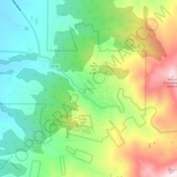
Nom : Carte topographique Austin, altitude, relief.
Lieu : Austin, Lander County, Nevada, United States (39.47326 -117.08954 39.51326 -117.04954)
Altitude moyenne : 2’076 m
Altitude minimum : 1’841 m
Altitude maximum : 2’464 m
Austin is an unincorporated small town in, and former county seat of, Lander County, Nevada, United States. In 2020, the census-designated place of Austin had a population of 167. It is located on the western slopes of the Toiyabe Range at an elevation of 6,575 feet (2,004 m). U.S. Route 50 passes through the town.