
Carte topographique Padul
Carte interactive
Cliquez sur la carte pour afficher l’altitude.
À propos de cette carte
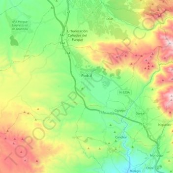
Nom : Carte topographique Padul, altitude, relief.
Altitude moyenne : 964 m
Altitude minimum : 508 m
Altitude maximum : 1’754 m
El Padul is a municipality of south-eastern Spain, in the province of Granada, within the comarca of el Valle de Lecrín. The population on 2008 was 8.440 inhabitants. This town is situated 13 km at the south of the city of Granada. Its altitude is 744 meters above the sea level.
Autres cartes topographiques
Cliquez sur une carte pour visualiser sa topographie, son altitude et son relief.
Restábal
Spain > Andalusia > Comarca del Valle de Lecrín > El Valle
Restábal, El Valle, Comarca del Valle de Lecrín, Granada, Andalusia, 18658, Spain
Altitude moyenne : 636 m