
Carte topographique Kunda
Cliquez sur la carte pour afficher l’altitude.
À propos de cette carte
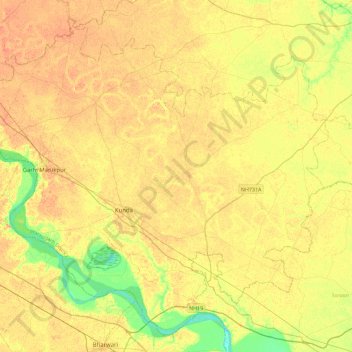
Nom : Carte topographique Kunda, altitude, relief.
Lieu : Kunda, Pratapgarh, Uttar Pradesh, India (25.57238 81.32497 25.93965 81.77562)
Altitude moyenne : 102 m
Altitude minimum : 80 m
Altitude maximum : 115 m
Autres cartes topographiques
Cliquez sur une carte pour visualiser sa topographie, son altitude et son relief.
Kunda
India > Uttar Pradesh > Pratāpgarh
Kunda is located at 25°43′N 81°31′E / 25.72°N 81.52°E / 25.72; 81.52. It has an average elevation of 9 metres (291 feet). Kunda is not a very old town and probably was founded during the British Raj. Kunda is Located on Prayagraj-Lucknow National Highway 24B. Place is developing as main…
Altitude moyenne : 103 m