
Carte topographique Ibex
Carte interactive
Cliquez sur la carte pour afficher l’altitude.
À propos de cette carte
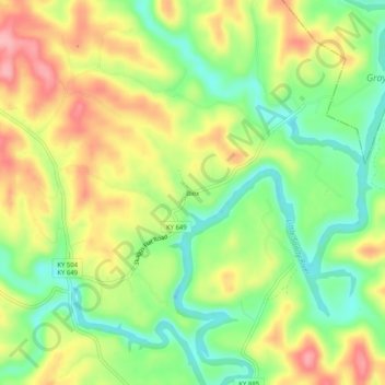
Nom : Carte topographique Ibex, altitude, relief.
Lieu : Ibex, Elliott County, Kentucky, United States (38.15619 -83.09351 38.19619 -83.05351)
Altitude moyenne : 249 m
Altitude minimum : 188 m
Altitude maximum : 319 m
Autres cartes topographiques
Cliquez sur une carte pour visualiser sa topographie, son altitude et son relief.
Culver
United States > Kentucky > Elliott County
Culver, Elliott County, Kentucky, United States
Altitude moyenne : 271 m
Stark
United States > Kentucky > Elliott County
Stark, Elliott County, Kentucky, United States
Altitude moyenne : 285 m
Newfoundland
United States > Kentucky > Elliott County
Newfoundland, Elliott County, Kentucky, 41171, United States
Altitude moyenne : 259 m
Sandy Hook
United States > Kentucky > Elliott County
Sandy Hook, Elliott County, Kentucky, United States
Altitude moyenne : 261 m
Isonville
United States > Kentucky > Elliott County
Isonville, Elliott County, Kentucky, 41149, United States
Altitude moyenne : 275 m