
Carte topographique Areal Gordo
Carte interactive
Cliquez sur la carte pour afficher l’altitude.
À propos de cette carte
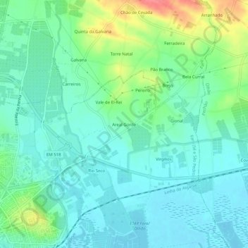
Nom : Carte topographique Areal Gordo, altitude, relief.
Lieu : Areal Gordo, Faro (Sé e São Pedro), Faro, 8005-409, Portugal (37.01463 -7.92260 37.05463 -7.88260)
Altitude moyenne : 19 m
Altitude minimum : -1 m
Altitude maximum : 70 m
Autres cartes topographiques
Cliquez sur une carte pour visualiser sa topographie, son altitude et son relief.
Alcaria Cova
Alcaria Cova, Conceição e Estoi, Faro, 8005-405, Portugal
Altitude moyenne : 181 m
Bela Curral
Bela Curral, Conceição e Estoi, Faro, 8005-418, Portugal
Altitude moyenne : 30 m
Santa Bárbara de Nexe
Santa Bárbara de Nexe, Faro, Portugal
Altitude moyenne : 160 m
Quinta das Raposeiras
Portugal > Faro > Faro > Quinta das Raposeiras
Quinta das Raposeiras, Santa Bárbara de Nexe, Faro, 8005-423, Portugal
Altitude moyenne : 256 m
Praia da Ilha de Faro
Portugal > Faro > Faro > Almancil
Praia da Ilha de Faro, Almancil, Faro, Loulé, Faro, Portugal
Altitude moyenne : 1 m