
Carte topographique Porcupine District
Carte interactive
Cliquez sur la carte pour afficher l’altitude.
À propos de cette carte
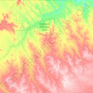
Nom : Carte topographique Porcupine District, altitude, relief.
Altitude moyenne : 925 m
Altitude minimum : 720 m
Altitude maximum : 1’122 m
Autres cartes topographiques
Cliquez sur une carte pour visualiser sa topographie, son altitude et son relief.
Red Shirt
United States > South Dakota > Oglala Lakota County
Red Shirt, White Clay District, Oglala Lakota County, South Dakota, United States
Altitude moyenne : 845 m
Badlands National Park
United States > South Dakota > Oglala Lakota County
Badlands National Park, Oglala Lakota County, South Dakota, 57750, United States
Altitude moyenne : 848 m