
Carte topographique Grantham
Cliquez sur la carte pour afficher l’altitude.
À propos de cette carte
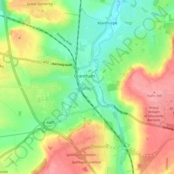
Nom : Carte topographique Grantham, altitude, relief.
Altitude moyenne : 84 m
Altitude minimum : 43 m
Altitude maximum : 135 m
Autres cartes topographiques
Cliquez sur une carte pour visualiser sa topographie, son altitude et son relief.
Scottlethorpe
United Kingdom > England > Lincolnshire > South Kesteven > Edenham
Altitude moyenne : 49 m
Moor Barn
United Kingdom > England > Lincolnshire > South Kesteven > Hough-on-the-Hill
Altitude moyenne : 31 m
Witham on the Hill
United Kingdom > England > Lincolnshire > South Kesteven > Witham on the Hill
Altitude moyenne : 43 m
Old Somerby
United Kingdom > England > Lincolnshire > South Kesteven > Old Somerby
Altitude moyenne : 115 m
Woolsthorpe-by-Belvoir
United Kingdom > England > Lincolnshire > South Kesteven
Altitude moyenne : 82 m
Sempringham
United Kingdom > England > Lincolnshire > South Kesteven > Pointon
Sempringham consists of a church and a holy well, with other houses east from the church scattered along the B1177 between Pointon and Billingborough. The church stands at an altitude of about 52 feet (16 m), on land rising out of flat fenland. Pointon is the chief township of the civil parish, which includes…
Altitude moyenne : 16 m
Uffington Park
United Kingdom > England > Lincolnshire > South Kesteven > Uffington
Altitude moyenne : 30 m
Careby
United Kingdom > England > Lincolnshire > South Kesteven > Little Bytham
Altitude moyenne : 56 m
Little Humby
United Kingdom > England > Lincolnshire > South Kesteven > Ropsley
Altitude moyenne : 81 m
Little Haw Wood
United Kingdom > England > Lincolnshire > South Kesteven > Castle Bytham
Altitude moyenne : 92 m
Grimsthorpe
United Kingdom > England > Lincolnshire > South Kesteven > Grimsthorpe
Altitude moyenne : 55 m
Uffington
United Kingdom > England > Lincolnshire > South Kesteven > Uffington
Altitude moyenne : 30 m
Stainfield
United Kingdom > England > Lincolnshire > South Kesteven > Hanthorpe
Altitude moyenne : 40 m