
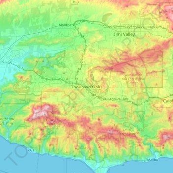
Carte topographique Thousand Oaks
Carte interactive
Cliquez sur la carte pour afficher l’altitude.
À propos de cette carte
Nom : Carte topographique Thousand Oaks, altitude, relief.
Altitude moyenne : 288 m
Altitude minimum : 0 m
Altitude maximum : 918 m
Autres cartes topographiques
Cliquez sur une carte pour visualiser sa topographie, son altitude et son relief.
Thousand Oaks
United States > California > Ventura County > Thousand Oaks
Thousand Oaks, Ventura County, California, United States
Altitude moyenne : 303 m
Newbury Park
United States > California > Ventura County > Thousand Oaks
Newbury Park, Thousand Oaks, Ventura County, CAL Fire Southern Region, California, 91320, United States
Altitude moyenne : 262 m
Greenwich Village
United States > California > Ventura County > Thousand Oaks
Greenwich Village, Thousand Oaks, Ventura County, CAL Fire Southern Region, California, 91360, United States
Altitude moyenne : 275 m
Westlake Village
United States > California > Ventura County > Thousand Oaks
Westlake Village, Thousand Oaks, Ventura County, CAL Fire Southern Region, California, 91361, United States
Altitude moyenne : 305 m
Ventu Park
United States > California > Ventura County > Thousand Oaks > Newbury Park
Ventu Park, Newbury Park, Thousand Oaks, Ventura County, CAL Fire Southern Region, California, 91320, United States
Altitude moyenne : 250 m