
Faire un don
Équipez-vous pour votre prochaine aventure :
En tant que Partenaire Amazon, ce site perçoit une commission sur les achats éligibles sans surcoût pour vous.
Carte topographique Honey Grove
Cliquez sur la carte pour afficher l’altitude.
Faire un don
Équipez-vous pour votre prochaine aventure :
En tant que Partenaire Amazon, ce site perçoit une commission sur les achats éligibles sans surcoût pour vous.
Honey Grove
Honey Grove is in central North Texas, in eastern Fannin County, 16 miles (26 km) east of Bonham, the county seat, 39 miles (63 km) north of Greenville, 42 miles (68 km) east of Sherman, and 90 miles (140 km) northeast of the central business district of Dallas. Honey Grove was developed on flat to gently rolling terrain with scattered trees. The city is at an elevation ranging from about 580 to 690 feet (180 to 210 m) above sea level. U.S. Highway 82 and State Highway 56 traverse the city from east to west, and State Roads 34, 100, and 824 run north and south. Bonham is the closest major economic center. Its climate produces an annual average daily maximum temperature of 75.1 °F, and an average annual rainfall is 43.99 inches (1,117 mm). It is also a part of the Texoma region.
Faire un don
Équipez-vous pour votre prochaine aventure :
En tant que Partenaire Amazon, ce site perçoit une commission sur les achats éligibles sans surcoût pour vous.
À propos de cette carte
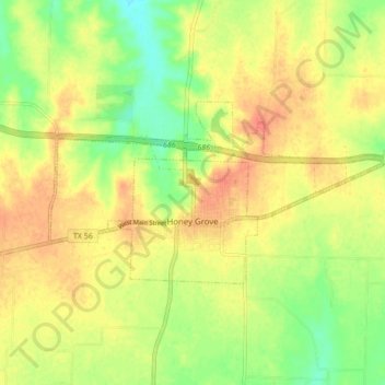
Nom : Carte topographique Honey Grove, altitude, relief.
Lieu : Honey Grove, Fannin County, Texas, 75446, United States (33.57186 -95.94192 33.60558 -95.85660)
Altitude moyenne : 195 m
Altitude minimum : 169 m
Altitude maximum : 215 m
Faire un don
Équipez-vous pour votre prochaine aventure :
En tant que Partenaire Amazon, ce site perçoit une commission sur les achats éligibles sans surcoût pour vous.
Autres cartes topographiques
Cliquez sur une carte pour visualiser sa topographie, son altitude et son relief.
Faire un don
Équipez-vous pour votre prochaine aventure :
En tant que Partenaire Amazon, ce site perçoit une commission sur les achats éligibles sans surcoût pour vous.
Faire un don
Équipez-vous pour votre prochaine aventure :
En tant que Partenaire Amazon, ce site perçoit une commission sur les achats éligibles sans surcoût pour vous.