
Carte topographique Village of Mamaroneck
Carte interactive
Cliquez sur la carte pour afficher l’altitude.
Village of Mamaroneck
Other areas of the town include Heathcote Hill, overlooking the harbor, Harbor Heights (the heights) to the northeast, Old Rye Neck (settled in the 1880s), Rye Neck (settled in the 1920s and 1930s), Orienta, and Washingtonville, better known as "The Flats", due to the flat, low-lying topography of the area.
À propos de cette carte
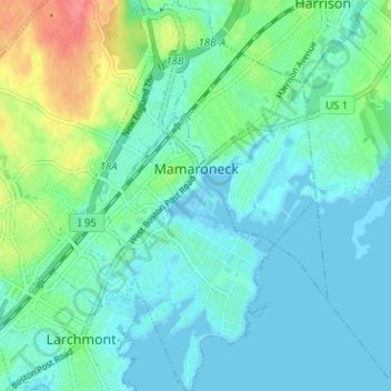
Nom : Carte topographique Village of Mamaroneck, altitude, relief.
Altitude moyenne : 15 m
Altitude minimum : -3 m
Altitude maximum : 65 m
Autres cartes topographiques
Cliquez sur une carte pour visualiser sa topographie, son altitude et son relief.
Ward Pound Ridge Reservation
United States > New York > Westchester County > Town of Pound Ridge
Altitude moyenne : 164 m
Riveredge Trailer Park
United States > New York > Westchester County > Town of Cortlandt > Verplanck
Altitude moyenne : 14 m
Isle of San Souci
United States > New York > Westchester County > City of New Rochelle
Altitude moyenne : 7 m
Wykagyl Park
United States > New York > Westchester County > City of New Rochelle
Altitude moyenne : 41 m
Lake Waccabuc
United States > New York > Westchester County > Town of Lewisboro > Waccabuc
Altitude moyenne : 173 m
Sherman Park
United States > New York > Westchester County > Town of Mount Pleasant > Thornwood
Altitude moyenne : 133 m
Mariandale
United States > New York > Westchester County > Village of Ossining
Altitude moyenne : 53 m
Pleasantside
United States > New York > Westchester County > Town of Cortlandt
Altitude moyenne : 108 m
Salem Center
United States > New York > Westchester County > Town of North Salem
Altitude moyenne : 147 m
Bonnie Crest
United States > New York > Westchester County > City of New Rochelle
Altitude moyenne : 58 m
Vernon Park
United States > New York > Westchester County > City of Mount Vernon
Altitude moyenne : 31 m
Lake Mohansic
United States > New York > Westchester County > Town of Yorktown
Altitude moyenne : 159 m
West Harrison Village Green
United States > New York > Westchester County > Town/Village of Harrison > East White Plains
Altitude moyenne : 79 m
Colonial Heights
United States > New York > Westchester County > City of Yonkers
Altitude moyenne : 60 m
Sedge Island
United States > New York > Westchester County > City of New Rochelle
Altitude moyenne : 47 m
Crestwood Gardens
United States > New York > Westchester County > City of Yonkers
Altitude moyenne : 65 m
Jefferson Valley
United States > New York > Westchester County > Jefferson Valley-Yorktown
Altitude moyenne : 178 m
Chauncey
United States > New York > Westchester County > Village of Dobbs Ferry
Altitude moyenne : 76 m
Fenmore Park
United States > New York > Westchester County > Town/Village of Harrison
Altitude moyenne : 38 m
Shore Acres
United States > New York > Westchester County > Village of Mamaroneck
Altitude moyenne : 11 m
Bronxville Heights
United States > New York > Westchester County > City of Yonkers
Altitude moyenne : 63 m
Mount Hope
United States > New York > Westchester County > Village of Hastings-on-Hudson
Altitude moyenne : 60 m
New York, Westchester and Boston Railway
United States > New York > Westchester County > Village of Pelham > North Pelham
Altitude moyenne : 28 m
Sleepy Hollow Manor
United States > New York > Westchester County > Village of Sleepy Hollow > Sleepy Hollow Manor
Altitude moyenne : 41 m
Spring Valley
United States > New York > Westchester County > Town of Ossining > Ossining > Spring Valley
Altitude moyenne : 115 m
Whitehall Corners
United States > New York > Westchester County > Town of Somers
Altitude moyenne : 97 m
Sarles Corners
United States > New York > Westchester County > Town of Pound Ridge
Altitude moyenne : 141 m
Secor Gardens
United States > New York > Westchester County > Village of Scarsdale
Altitude moyenne : 70 m