
Carte topographique Impasugong
Carte interactive
Cliquez sur la carte pour afficher l’altitude.
À propos de cette carte
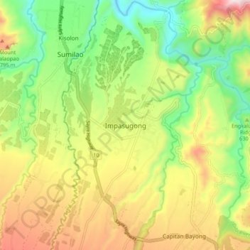
Nom : Carte topographique Impasugong, altitude, relief.
Lieu : Impasugong, Bukidnon, Northern Mindanao, Philippines (8.26605 124.95754 8.34605 125.03754)
Altitude moyenne : 613 m
Altitude minimum : 323 m
Altitude maximum : 993 m
Cool and moist throughout the year due to its high elevation ranging from 500 metres (1,600 ft) to more than 1,000 metres (3,300 ft) above sea level. It is a typhoon-free area ideal for the production of high value crops. Average temperature ranges from 16 to 31 °C (61 to 88 °F) throughout the year.
Autres cartes topographiques
Cliquez sur une carte pour visualiser sa topographie, son altitude et son relief.
Mount Tuminungan
Philippines > Bukidnon > Impasugong
Mount Tuminungan, Impasugong, Bukidnon, Northern Mindanao, Philippines
Altitude moyenne : 2’352 m