
Carte topographique دهستان بندر امام خمینی
Carte interactive
Cliquez sur la carte pour afficher l’altitude.
À propos de cette carte
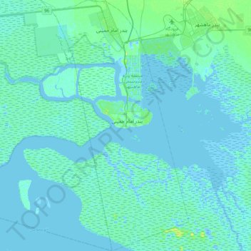
Nom : Carte topographique دهستان بندر امام خمینی, altitude, relief.
Altitude moyenne : 2 m
Altitude minimum : -11 m
Altitude maximum : 19 m
Autres cartes topographiques
Cliquez sur une carte pour visualiser sa topographie, son altitude et son relief.
Chamran Town
Iran > Khuzestan Province > Bandar-e-Mahshahr County > دهستان جراحی
Chamran Town, دهستان جراحی, بخش مرکزی, Bandar-e-Mahshahr County, Khuzestan Province, Iran
Altitude moyenne : 13 m