
Carte topographique Grass Valley
Carte interactive
Cliquez sur la carte pour afficher l’altitude.
À propos de cette carte
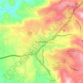
Nom : Carte topographique Grass Valley, altitude, relief.
Lieu : Grass Valley, Nevada County, California, United States (39.19381 -121.08282 39.24440 -121.00559)
Altitude moyenne : 775 m
Altitude minimum : 618 m
Altitude maximum : 921 m
Grass Valley is a city in Nevada County, California, United States. Situated at roughly 2,500 feet (760 m) elevation in the western foothills of the Sierra Nevada mountain range, this historic northern Gold Country city is 57 miles (92 km) by car from the state capitol in Sacramento, 64 miles (103 km) from Sacramento International Airport, 88 miles (142 km) west of Reno, and 143 miles (230 km) northeast of San Francisco. As of the 2010 United States Census, its population was 12,860.
Autres cartes topographiques
Cliquez sur une carte pour visualiser sa topographie, son altitude et son relief.
Cypress Hill
United States > California > Nevada County > Grass Valley
Cypress Hill, Grass Valley, Nevada County, California, 95945, United States
Altitude moyenne : 786 m
Hills Flat
United States > California > Nevada County > Grass Valley
Hills Flat, Grass Valley, Nevada County, California, 95945, United States
Altitude moyenne : 802 m
Spring Hill
United States > California > Nevada County > Grass Valley > Spring Hill
Spring Hill, Grass Valley, Nevada County, California, 95954, United States
Altitude moyenne : 807 m
Boston Ravine
United States > California > Nevada County > Grass Valley
Boston Ravine, Grass Valley, Nevada County, California, 95945, United States
Altitude moyenne : 755 m