
Faire un don
Équipez-vous pour votre prochaine aventure :
En tant que Partenaire Amazon, ce site perçoit une commission sur les achats éligibles sans surcoût pour vous.
Carte topographique Hurley
Cliquez sur la carte pour afficher l’altitude.
Faire un don
Équipez-vous pour votre prochaine aventure :
En tant que Partenaire Amazon, ce site perçoit une commission sur les achats éligibles sans surcoût pour vous.
Hurley
Hurley was at the center of a boundary dispute between Michigan and Wisconsin, culminating in a United States Supreme Court case in 1926, confirming Hurley belonging to Wisconsin. The Montreal River was mapped in detail in 1841 by Lieutenant Thomas Jefferson Cram of the United States Land Office Department of Topography. Cram was assigned by Congress to survey the northeast boundary between Michigan and Wisconsin. This boundary had been originally outlined by Congress in 1834 on the basis of the faulty maps of the time which incorrectly showed both the Montreal and Menominee rivers originating from the Lac Vieux Desert in Vilas County. After a detailed survey, Cram located the headwaters of the Montreal 55 miles west of Lac Vieux Desert, and recommended the boundary line be run from the center of the lake to the headwaters of the Montreal. Michigan brought suit against Wisconsin to correct the boundary line between the two states. Michigan's claim included the City of Hurley and its valuable mineral deposits. Michigan's lawsuit, Michigan v. Wisconsin (270 U.S. 295, 1926), was dismissed by the US Supreme Court on the grounds that Wisconsin's long continued possession of the disputed property was acquiesced in by Michigan (P. 270, U.S. 301).
Faire un don
Équipez-vous pour votre prochaine aventure :
En tant que Partenaire Amazon, ce site perçoit une commission sur les achats éligibles sans surcoût pour vous.
À propos de cette carte
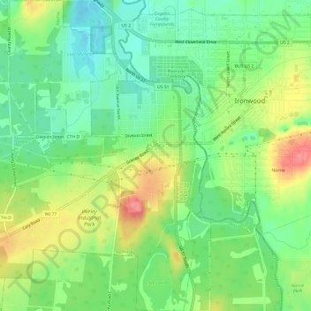
Nom : Carte topographique Hurley, altitude, relief.
Lieu : Hurley, Iron County, Wisconsin, United States (46.42761 -90.22094 46.46885 -90.17671)
Altitude moyenne : 455 m
Altitude minimum : 423 m
Altitude maximum : 503 m
Faire un don
Équipez-vous pour votre prochaine aventure :
En tant que Partenaire Amazon, ce site perçoit une commission sur les achats éligibles sans surcoût pour vous.
Autres cartes topographiques
Cliquez sur une carte pour visualiser sa topographie, son altitude et son relief.
Faire un don
Équipez-vous pour votre prochaine aventure :
En tant que Partenaire Amazon, ce site perçoit une commission sur les achats éligibles sans surcoût pour vous.
Manitowish River
United States > Wisconsin > Iron County > Town of Mercer > Manitowish
Altitude moyenne : 486 m