

Carte topographique Fort Wayne
Cliquez sur la carte pour afficher l’altitude.
Fort Wayne
The first settlement started in 1815. In 1819, the military garrison abandoned the fort and moved to Detroit. In 1822, a federal land office opened to sell land ceded by local Native Americans by the Treaty of St. Mary's in 1818. Platted in 1823 at the Ewing Tavern, the village became an important frontier outpost, and was incorporated as the Town of Fort Wayne in 1829, with a population of 300. The Wabash and Erie Canal's opening improved travel conditions to the Great Lakes and Mississippi River, exposing Fort Wayne to expanded economic opportunities. The population topped 2,000 when the town was incorporated as the City of Fort Wayne on February 22, 1840. Pioneer newspaperman George W. Wood was elected the city's first mayor. Fort Wayne's "Summit City" nickname dates from this period, referring to the city's position at the highest elevation along the canal's route. As influential as the canal was to the city's earliest development, it quickly became obsolete after briefly competing with the city's first railroad, the Pittsburgh, Fort Wayne and Chicago Railway, completed in 1854.
À propos de cette carte
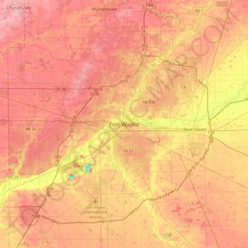
Nom : Carte topographique Fort Wayne, altitude, relief.
Lieu : Fort Wayne, Allen County, Indiana, 46802, United States (40.91999 -85.29860 41.23999 -84.97860)
Altitude moyenne : 248 m
Altitude minimum : 185 m
Altitude maximum : 280 m